Disclosure : This site contains affiliate links to products. We may receive a commission for purchases made through these links.
Greater London Collins Street Atlas
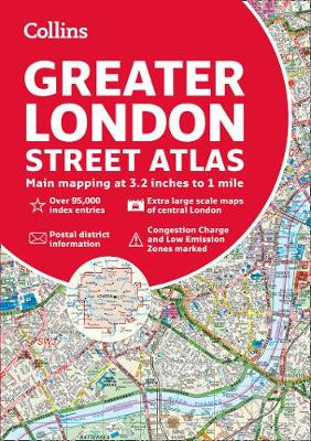
The ultimate street atlas of London, featuring incredibly detailed street level maps, with more than 40 categories of information, covering 1660 square miles in and around London and with more than 95,000 street names. This is the definitive reference atlas for London. Scale: 1:10,000 Central area, 1:20,000 Main area, 1:63,360 Urban maps. Coverage at 1:20,000 scale (3.2 inches to 1 mile) is from Welwyn Garden City in the north to Gatwick Airport in the south, and from Windsor in the west to Gravesend in the east. The 1:10,000 (6.3 inches to 1 mile) scale extends from Highbury in the north to Clapham in the south and from Shepherd`s Bush in the west to Beckton in the east. Also features:* London Underground map.* Airport plans.* Full index to street names and places of interest, also hospitals, schools, colleges and stations.

Related Products:
 London Collins Pocket Atlas
 London A-Z Big Street Atlas
 London A-Z Street Atlas
 Greater London A-Z Master Atlas
 London Philip`s Street Atlas De Luxe Edition Union Jack
 London Collins Handy Street Map
 London Philip`s Mini Street Atlas
 Discovering London Collins Illustrated Map
 Gloucestershire Philip`s Street Atlas
 Cornwall Philip`s Street Atlas
 Southampton A-Z Street Atlas
 Wiltshire and Swindon Philip`s Street Atlas
 Greater Manchester A-Z Street Atlas
 Belfast Collins Streetfinder Colour Atlas
 Surrey Philip`s Street Atlas
 Dorset Philip`s Street Atlas
 Edinburgh A-Z Street Atlas
 London A-Z Mini Street Atlas PAPERBACK
 Isle of Wight Street Atlas
 Norfolk Philip`s Street Atlas
 Derbyshire Philip`s Street Atlas
 Devon Philip`s Street Atlas
 Nottingham A-Z Street Atlas
 London Collins Pocket Map
 Portsmouth A-Z Street Atlas
 Brighton and Worthing A-Z Street Atlas
 Nottinghamshire Philip`s Street Atlas
 Cardiff A-Z Street Atlas
 London West End A-Z Mini Map
 Buckinghamshire and Milton Keynes Philip`s Street Atlas
 Greater Vienna F&B Street Atlas
 South East England A-Z Road Atlas
 Southampton – Eastleigh – Fawley – Hythe – Romsey A-Z Street Atlas
 London Rail Atlas: Fifth Edition
 Vancouver Greater and Fraser Valley Street Atlas Deluxe Edition
 Central London A-Z Map
 London Railway Atlas
 Barcelona: Greater Barcenona Telstar Street Atlas
 London Bensons MapGuides Street Map
 London A-Z Visitor`s Atlas & Guide