Disclosure : This site contains affiliate links to products. We may receive a commission for purchases made through these links.
Great Britain & Ireland Flexi Map
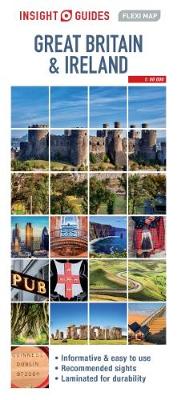
Great Britain and Ireland on an Insight Flexi Pocket Map in their new format introduced to provide more convenient access to the special features of this series: various additional maps and/or street plans plus tourist information including a list of must-see sights. The map is tear-resistant, waterproof, and can be written on with non-permanent marker pens. On one side is a road map showing the network of main road and railway connections on a base indicating physical geography by colouring with names of mountain ranges and highlighting selected places of interest. PLEASE NOTE: the map scale is incorrectly given at 1:500,000. The map is indexed for places and points of interest.On the reverse are this title’s additional features:- A road map at 1:330,000 of the Greater London area within the M25 motorway but including Windsor, St. Albans and the Royal Horticultural Society garden at Wisley. The map is indexed for places and point of interest.- A diagram of the Transport for London Underground and Overground network.- 33 main sights, neatly grouped into sections covering Top Museums & Galleries, Top Royal Homes, Best Gardens, plus Important Ancient Sites, are given brief descriptions and are prominently highlighted on the relevant maps.- Information about Getting Around and Facts for Visitors, including tourist information, money, opening times, telecommunications, plus monthly climate charts.To see the list of other Insight Flexi titles in this series please click on the series link.

Related Products:
 Great Britain: Sustrans/CycleCity Cycling Maps of Great Britain & Northern Ireland
 Great Britain: A-Z Visitors` Maps and Atlases
 Kuala Lumpur Flexi Map
 Great Britain – Ireland Michelin Pocket Map
 Great Britain & Northern Ireland ReiseKnow-How Map
 Great Britain: Michelin 400K Road Maps
 Great Britain & Northern Ireland A-Z Road Atlas 2022 A3 PAPERBACK
 Great Britain & Northern Ireland A-Z Road Atlas 2021 A3 PAPERBACK
 Amsterdam Flexi Map
 Great Britain & Northern Ireland A-Z Road Atlas 2023 A3 PAPERBACK
 Montreal Flexi Map OUT OF PRINT
 Macau Flexi Map
 Barcelona Flexi Map
 Great Britain & Northern Ireland A-Z Super Scale Road Atlas 2022 A3 SPIRAL-BOUND
 Great Britain: A-Z Regional Road Maps and Atlases
 Great Britain & Ireland Michelin Main Roads Atlas 2021 SPIRAL-BOUND
 Great Britain & Ireland Michelin Main Roads Atlas 2021 A4 PAPER
 Great Britain: Ordnance Survey Tour Maps
Great Britain & Northern Ireland A-Z Super Scale Road Atlas 2023 A3 SPIRAL-BOUND
Great Britain: Ordnance Survey Tour Maps
Great Britain & Northern Ireland A-Z Super Scale Road Atlas 2023 A3 SPIRAL-BOUND
 Budapest Flexi Map
Great Britain: Philip`s Road Atlases
Budapest Flexi Map
Great Britain: Philip`s Road Atlases
 Great Britain: Michelin Regional Tourist Maps
 Great Britain & Ireland: Rucksack Readers` Guides to Long-distance Footpaths
 Britain and Northern Ireland Collins Essential Road Atlas 2021
 Turkey Flexi Map
Great Britain and Ireland: Harvey Superwalker & Ultramap Maps
Turkey Flexi Map
Great Britain and Ireland: Harvey Superwalker & Ultramap Maps
 Britain and Ireland Philip`s Road Map
Britain and Northern Ireland Collins Essential Road Atlas 2022 A4 SPIRAL-BOUND
Britain and Ireland Philip`s Road Map
Britain and Northern Ireland Collins Essential Road Atlas 2022 A4 SPIRAL-BOUND
 Great Britain: Philip`s Navigator Regional Road Atlases
 Britain`s Butterflies: A Field Guide to the Butterflies of Great Britain and Ireland – Fully Revised and Updated Fourth Edition
 Great Britain and Ireland: Quail Railway Track Diagrams
 Great Britain: The Daily Telegraph Wall Map of Great Britain & Ireland (ENCAPSULATED)
 Britain & Ireland Philip`s Big Road Atlas 2017
 Great Britain & Ireland 2021 Michelin
 Great Britain: A-Z Regional Wall Maps
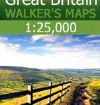 Great Britain: AA/Ordnance Survey 25K Walker`s Maps
 I Love the Seaside Great Britain & Ireland: The Surf & Travel Guide to Great Britain & Ireland
 Great Britain: OS 25K Explorer Maps (Paper and Waterproof Editions)
Britain and Northern Ireland Collins Big Road Atlas 2023 A3 PAPERBACK
Great Britain: OS 25K Explorer Maps (Paper and Waterproof Editions)
Britain and Northern Ireland Collins Big Road Atlas 2023 A3 PAPERBACK