Disclosure : This site contains affiliate links to products. We may receive a commission for purchases made through these links.
Golfe du Morbihan – Vannes IGN Pocket Map M0921OT


Related Products:
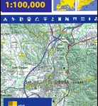
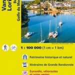 Vannes – Lorient – Belle-รฎle Golfe du Morbihan IGN TOP100 123
 Vannes – Golfe du Morbihan IGN 0921OT
 Vannes – Golfe du Morbihan IGN WATERPROOF 0921OTR
 Golfe du Morbihan – Belle-รle et Groix – Presqu`รle de Quiberon IGN 75017
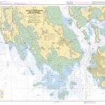
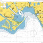
 SHOM Chart 7137 – Golfe du Morbihan
SHOM Chart 7137L – Golfe du Morbihan – Leisure A4 size
SHOM Chart 7137 – Golfe du Morbihan
SHOM Chart 7137L – Golfe du Morbihan – Leisure A4 size
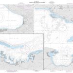
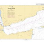
 SHOM Chart 7358 – Iles Kerguelen – Golfe du Morbihan – Partie Est
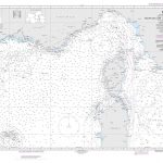
 SHOM Chart 7359 – Iles Kerguelen – Golfe du Morbihan (partie Ouest)
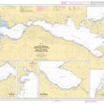
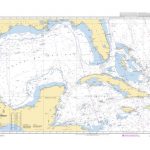
 SHOM Chart 7107 – Port de la Trinitรฉ-Sur-Mer, Port du Crouesty-Entrรฉe du Golfe du Morbihan
SHOM Chart 7107L – Port de la Trinitรฉ-Sur-Mer, Port du Crouesty-Entrรฉe du Golfe du Morbihan – Leisure A4 size
SHOM Chart 7107 – Port de la Trinitรฉ-Sur-Mer, Port du Crouesty-Entrรฉe du Golfe du Morbihan
SHOM Chart 7107L – Port de la Trinitรฉ-Sur-Mer, Port du Crouesty-Entrรฉe du Golfe du Morbihan – Leisure A4 size
 SHOM Chart 7205 – Golfe de La Napoule – Golfe Juan – Iles de Lรฉrins – Abords de Cannes
 Admiralty Chart 2247 – Golfe de la Napoule and Golfe Juan
 SHOM Chart 7205L – Golfe de La Napoule – Golfe Juan – Iles de Lรฉrins – Abords de Cannes – Leisure A4 size
 Vannes Blay-Foldex Street Plan
 SHOM Chart 7253L – Golfe de Corinthe (Korinthiakรณs Kรณlpos) – Golfe de Pรกtras (Patraรฏkรณs Kรณlpos) – Leisure A4 size
 SHOM Chart 7253 – Golfe de Corinthe (Korinthiakรณs Kรณlpos) – Golfe de Pรกtras (Patraรฏkรณs Kรณlpos)
 Le Morbihan by Bike IGN VEL05
 Finistere – Morbihan Michelin Local 308
 Le Morbihan ร pied D056
 Cotes-d`Armor – Morbihan IGN D721316
 Propriano – Golfe De Valinco IGN 4154OT
 Bastia – Golfe de Saint-Florent IGN 4348OT
 Vico – Cargese – Golfe de Sagone – PNR de Corse IGN 4151OT
 Admiralty Chart 155 – Golfe and Port de Fos
 SHOM Chart 7280 – Golfe d’Ajaccio
 NGA Chart 26188 – Plans in the Golfe de la Gonave
 NGA Chart 53031 – Golfe du Lion to Tyrrhenian Sea
 SHOM Chart 6761 – Golfe du Mexique
 SHOM Chart 6684 – Golfe et Port de Fos
 SHOM Chart 6961 – Golfe de La Spezia
 SHOM Chart 7316 – Golfe de Sagone
 SHOM Chart 7335 – Golfe de Palma
 SHOM Chart 7772 – Golfe d`Asinara
 SHOM Chart 6711 – Golfe de Napoli
 SHOM Chart 7254 – Golfe d’Athรจnes
 565 Golfe de Gascogne – SHOM Tidal Stream Atlas
 SHOM Chart 6911 – Golfe de Porto-Vecchio
 SHOM Chart 7580 – Ports du Golfe de Guinรฉe
 SHOM Chart 7800 – Golfe d`Aden et approches
 Admiralty Chart 2114 – Ports in the Golfe du Lion