Disclosure : This site contains affiliate links to products. We may receive a commission for purchases made through these links.
Gettysburg National Miltary Park
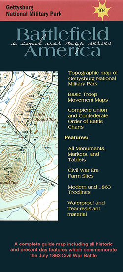
Gettysburg National Military Park in Pennsylvania on a contoured map from Trailhead Graphics, showing locations of historic sites and monuments of the battle in 1863, maps of troop movements, order of battle charts, etc.Printed on light, waterproof and tear-resistant plastic paper, the map covers the Gettysburg National Military Park and the adjoining Eisenhower National Historic Site at 1:12,000. Topography of the area is clearly shown by contours at 10 feet (3.05 metres) intervals, with colouring indicating present-day woods, plus woods and orchards at the time of the battle in 1863. Symbols, colour-coded to indicate Union and Confederate forces, show locations of headquarters monuments, markers and tablets, and are cross-referenced to a list next to the map. Also marked are various facilities for visitors to the park: information centre, car parks, picnic areas, toilets and the amphitheatre.On the reverse two sections of the main map are shown in greater detail at 1:6,000, with an additional panel providing the coverage of the East Cavalry Battlefield east of the main site. Also provided are maps showing troop movements on 1st, 2nd and 3rd July 1983, plus order of battle chards for the Union and the Confederate armies.

Related Products:
 South Downs National Park: An Archaeological Walking Guide
 Grasslands National Park: East Block, Saskatchewan
 Banff National Park Gem Trek
 Stelvio National Park Walking Guide – Italy`s Largest Alpine National Park
 Dzukija National Park
ลฝemaitija National Park
Aukลกtaitijos National Park
Curonian Spit National Park
Dzukija National Park
ลฝemaitija National Park
Aukลกtaitijos National Park
Curonian Spit National Park
 Bavarian Forest National Park – Nature Park East UK50-29
 Drawienski (Drawno) National Park
 Grand Canyon National Park East AZ
Auyuittuq National Park, Nunavut
Grand Canyon National Park East AZ
Auyuittuq National Park, Nunavut
 Richtersveld National Park and Northern Namaqualand
Puszcza Kampinoska – Kampinoski National Park
Richtersveld National Park and Northern Namaqualand
Puszcza Kampinoska – Kampinoski National Park
 Bialowieza / Puszcza Bialowieska National Park
 Broads National Park Pocket Map
 Dzukija National Park East
 Shivapuri Nagarjun National Park
 Chitwan National Park
 Kilimanjaro National Park
Nahanni National Park Reserve, Northwest Territories
Kilimanjaro National Park
Nahanni National Park Reserve, Northwest Territories
 Torres del Paine: Chile`s Premier National Park and Argentina`s Los Glaciares National Park
 Kruger National Park
Wapusk National Park, Manitoba
Sirimilik National Park, Nunavut
Ukkusiksalik National Park, Nunavut
Vuntut National Park, Yukon
Ivvavik National Park, Yukon
Kruger National Park
Wapusk National Park, Manitoba
Sirimilik National Park, Nunavut
Ukkusiksalik National Park, Nunavut
Vuntut National Park, Yukon
Ivvavik National Park, Yukon
 Sareks National Park Lantmateriet BD10
 Peneda-Geres National Park
 Los Glaciares National Park
Aulavik National Park, Northwest Territories
Los Glaciares National Park
Aulavik National Park, Northwest Territories
 London National Park City – North East Quarter Urban Nature Map
 London National Park City – South East Quarter Urban Nature Map
 Berchtesgaden National Park – Watzmann Alpenverein KOMBI BY21
 Sallandse Heuvelrug National Park: Deventer – Raalte – Rijssen
 Arusha National Park
 South Downs National Park Pocket Map
 Grand Canyon National Park Map Pack Bundle – Trails Illustrated National Parks
 Rocky Mountain National Park Map Pack Bundle – Trails Illustrated National Parks