Disclosure : This site contains affiliate links to products. We may receive a commission for purchases made through these links.
Germany Postcode Map

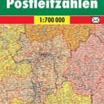
Postcode map of Germany at 1:700,000 from Bacher Verlag showing the division of the country into postal zones, regions and districts, as well as the division into states (Bavaria, Brandenburg, etc), with road and rail networks shown in the background.Colouring indicates division of the country into postal zones, and within each zone boundaries of postal regions and districts. Individual locations shown on the map are annotated with their 5-digit postal codes. Also shown are boundaries of the states forming the Federal Republic. In the backgrounds is a map of the country’s road network. The map has no indexed.

Related Products:
 Poland F&B Postcode Freytag & Berndt Wall Map
 Italy Postcode Freytag & Berndt Wall Map
 Austria F&B Postcode Map
 Postcode Atlas of Britain and Northern Ireland
 Germany F&B Postcode Map
 Switzerland K+F Postcode Wall Map
 Germany: ADAC Regional Street Atlases
 Great Britain: Map Marketing District Postcode Maps
 Great Britain & Northern Ireland: Map Marketing Postcode Sector Maps
 Germany Administrative F&B Wall Map
 Madrid Postcodes Telstar Map
 USA AA Big Road Atlas
 Europe F&B Postcode Map
 Hamburg – Lรผbeck – Lรผneburg ADAC Street Atlas
 Germany North F&B
 Karnataka Map-Guide
 Germany South F&B
 Germany Adventure Map
 Mexico Road Map
 Germany: BKG 200K Topographic Maps
 Germany NGS Classic Wall Map PAPER
 Hanover – Hildesheim – Celle ADAC Street Atlas
 Germany North High 5 Edition Road Map
 Indian Country NGS Wall Map PAPER
 Switzerland K+F Administrative Map
 Saarland – West Palatinate ADAC Street Atlas
Berlin – Potsdam Region ADAC Street Atlas
Saarland – West Palatinate ADAC Street Atlas
Berlin – Potsdam Region ADAC Street Atlas
 Cologne – Bonn – Aachen – Koblenz – Leverkusen ADAC Street Atlas
 Nuremberg – Ansbach – Bamberg – Bayreuth – Erlangen – Fรผrth ADAC Street Atlas
 Goa
Goa
 Munich – Augsburg – Erding – Ingolstadt – Landshut ADAC Street Atlas
 Germany Landscapes: Names and Boundaries
 Stuttgart – Heilbronn – Gรถppingen – Pforzheim – Reutlingen – Rottweil ADAC Street Atlas
Rhine-Main – Frankfurt – Aschaffenburg – Darmstadt – Mainz – Wiesbaden ADAC Street Atlas
Stuttgart – Heilbronn – Gรถppingen – Pforzheim – Reutlingen – Rottweil ADAC Street Atlas
Rhine-Main – Frankfurt – Aschaffenburg – Darmstadt – Mainz – Wiesbaden ADAC Street Atlas
 Jharkhand
 Germany High 5 Edition Road Map
 East Westphalia – Lippe – Bielefeld – Detmold – Gรผtersloh – Minden – Paderborn ADAC Street Atlas
 Abuja
Abuja
 Germany South High 5 Edition Road Map