Disclosure : This site contains affiliate links to products. We may receive a commission for purchases made through these links.
Germany North Marco Polo Zoom Map
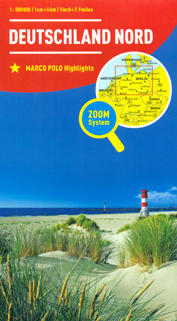
Northern Germany at 1:500,000 on a large road map from MairDumont with prominent highlighting of interesting locations, 10 more detailed enlargements for environs of main towns, plus an index booklet with 18 city maps and brief descriptions of 15 selected top sights, etc. Coverage extends south to Cologne, Erfurt and Dresden.Road network includes selected minor roads, highlights scenic roads and special tourist routes, shows intermediate driving distances on main roads, and indicates motorway services, toll stations, caravan and vehicle restrictions, etc. Railway lines, ferry routes and local airports are included, as well as administrative divisions with names of the states. Locations of interest are prominently highlighted, with separate colouring for towns or villages and for natural sites. Symbols show locations of campsites, youth hostels, etc. National parks and other protected areas are marked and topography is presented by relief shading with plenty of names of mountain ranges, valleys, etc. Latitude and longitude lines are drawn at 30` intervals. Multilingual map legend includes English.On the reverse are 10 large panels with enlargements showing in greater detail the environs of Berlin, Braunschweig, Bremen, Cologne – Bonn, Dresden, Hamburg, Hannover, Leipzig, Rostock, plus the Ruhr including Dortmund, Dรผsseldorf and Leverkusen. A separate 95-page booklet attached to the map cover includes an index which also lists national parks, UNESCO World Heritage sites, airports and amusement parks. The booklet also contains brief descriptions of 15 most interesting locations prominently highlighted on the map, plus street plans of central Berlin, Braunschweig, Bremen, Cologne, Dortmund, Dresden, Dรผsseldorf, Essen, Erfurt, Hamburg, Hannover, Kiel, Leipzig, Lรผbeck, Magdeburg, Potsdam, Rostock and Schwerin.A fold-out flap in the cover shows for route planning an overview of the whole area covered by the map plus the adjacent regions, prominently highlighting main places of interest, with the grid reference system in the margins making it easier to find locations on the main map. Also included are a distance/driving times table and basic driving regulations.

Related Products:
 Germany South Marco Polo Zoom Map
 North Rhine-Westphalia Marco Polo Regional Map 5
 Ireland Marco Polo Map
 Germany 700K F&B
 Netherlands Marco Polo Map
 Romania Marco Polo Map
 USA West Marco Polo Map
 Italy Marco Polo Map
 Germany: Marco Polo 200K Regional Road Maps
 Thuringia Marco Polo Regional Map 7
 Bavaria North Marco Polo Regional Map 12
 France Marco Polo Map
 Spain – Portugal Marco Polo Map
 Saxony Marco Polo Regional Map 9
 Portugal Marco Polo Map
 Belgium – Luxembourg Marco Polo Map
 Sweden Marco Polo Map
 Germany Administrative F&B Wall Map
 Germany Marco Polo Road Atlas 2021/2022
 USA East Marco Polo Map
 California Marco Polo Map
 Europe Marco Polo Map
Germany Marco Polo Road Atlas 2020/2021
Europe Marco Polo Map
Germany Marco Polo Road Atlas 2020/2021
 Germany West F&B
 Denmark Marco Polo Map
 USA Marco Polo Map
 Hesse Marco Polo Regional Map 6
 Saxony-Anhalt Marco Polo Regional Map 8
 South Africa – Namibia – Botswana Marco Polo Map
 Mecklenburg-Vorpommern Marco Polo Regional Map 2
 Bavaria South Marco Polo Regional Map 13
 Rhineland-Palatinate – Saarland Marco Polo Regional Map 10
 Schleswig-Holstein – Hamburg – Bremen Marco Polo Regional Map 1
 Brittany Marco Polo Map
 Canada Marco Polo Map
 Baden-Wurttemberg Marco Polo Regional Map 11
 Berlin – Brandenburg Marco Polo Regional Map 4
 Kenya Marco Polo Road Map
 Lower Saxony – Bremen – Hamburg Marco Polo Regional Map 3