Disclosure : This site contains affiliate links to products. We may receive a commission for purchases made through these links.
Geneva Once and Today Swisstopo Map No. 303
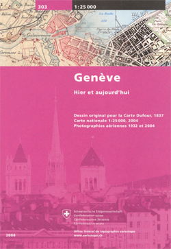
Geneva Once and Today map from Swisstopo, Switzerland’s national survey organization, with an excellent combination of two detailed topographic maps and two aerial photos, comparing presentation of the city at different stages in its development. One side shows the city and its environs on two topographic maps at 1:25,000: a beautiful colour reproduction of Swiss Survey’s famous ‘Dufourkarte” series drawn in 1837/1838, contrasting it with a map of the same area from 2004/2005.On the reverse there are two aerial images at 1:12,500: a black and white photo from 1932 with the same area photographed in colour in 2004. The accompanying text about the two topographic series and the two aerial imagery series is in French and German only.For the list of other titles in this series please click on the series link.

Related Products:
 Berne Once and Today Swisstopo Map No. 301
 Basel Once and Today Swisstopo Map No. 302
 Zurich Once and Today Swisstopo Map No. 304
 Geneva Swisstopo 270
 Geneva Swisstopo Hiking 270T
 Geneva PopOut
 Geneva Swisstopo 1301
 Geneva: Greater Geneva Street Plan
 Geneva & Switzerland ITMB
 Geneva
 Geneva Region K+F Hiking Map 21
 Switzerland: Ice & Glaciers Once and Today Swisstopo Map No. 306
 Geneva K+F Cycling Map 17
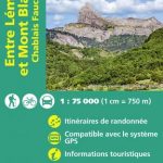
 Lake Geneva – Chablais – Faucigny
 Geneva – Mont Saleve Supertrail Map
 Zurich Geneva + Basel: The Monocle Travel Guide Series
 Lake Geneva Cycling Route Bikelein Map-Guide Compact
 The GR5 Trail – Lake Geneva to Nice
 Geneva CityPocket Street Plan
 Lake Geneva and Mont Blanc IGN 75007
 Sasso San Gottardo Once and Today Swisstopo Map No. 305
 The Geneva Option
 Geneva Hallwag 3in1 City Map
 La ViaRhรดna ร vรฉlo – from Lake Geneva to the Mediterranean FRENCH
Lausanne Swisstopo 261
La ViaRhรดna ร vรฉlo – from Lake Geneva to the Mediterranean FRENCH
Lausanne Swisstopo 261
 Rochers de Naye Swisstopo 262
 Dr Fischer of Geneva
 Switzerland: Swisstopo “Once and Today” Historical Maps
 England: An Aerial View
 Lausanne Swisstopo Hiking 261T
 Rochers de Naye Swisstopo Hiking 262T
 NOAA Chart 14828 – Erie to Geneva (Metric)
 Paul Temple and the Geneva Mystery
 Gotthard Railway Axis Once & Today Swisstopo Map No. 307
 French Alps – Via Ferratas – 66 Routes Between Geneva and Brianรงon
 Sardona Swisstopo SKI 247S
 Jungfrau Swisstopo SKI 264S
 Julierpass Swisstopo SKI 268S
 Montana Swisstopo SKI 273S
 Mischabel Swisstopo SKI 284S