Disclosure : This site contains affiliate links to products. We may receive a commission for purchases made through these links.
Garden Route & Route 62 Map Studio
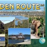
The Garden Route along South Africa’s southern coast on a double-sided map from Map Studio with coverage including an alternative route R62 further inland and GPS waypoints for main locations or road junctions. Numerous street maps, annotated with accommodation and tourist facilities, are provided for main towns.The map presents the route on a plain base with topographic information limited to rivers and colouring for nature reserves and other protected areas. Road network distinguishes between surfaced and untarred roads, shows distances on main routes and is annotated with GPS waypoints for important junctions. The map also shows railway lines and highlights numerous places of interest. Additional latitude and longitude margin ticks are given at intervals of 15’. Insets provide street plans showing accommodation and various places of interest or tourist facilities in: Montagu, Barrydale, Ladismith, Oudtshoorn, Mossel Bay, George, the Knysna Lagoon area with an enlargement for Central Waterfront, Plettenberg Bay, Humansdorp and Jeffreys Bay. National parks and protected areas have panels listing various activities and/or facilities available there, and similar information is provided for several of the towns along the route.To see the other titles in this series please click on the series link.

Related Products:
 Namibia Map Studio Adventure Map
 Western Cape Map Studio
 Zimbabwe Map Studio Adventure Map
 Namibia Map Studio Road Atlas
 South Africa Map Studio Road Atlas A4 PAPERBACK
 Stromberg-Murrtal Cycle Route – Idyllic Route
 Cape Town – Western Cape Towns Map Studio Street Atlas
 Malawi Map Studio Adventure Map
 International Dollard Route – German Fehn Route Bikeline Map-Guide
 Botswana Map Studio Adventure Map
 Munich-Venice Long Distance Cycle Route – incl Dolomites Route Bikeline Map-Guide
 Iller Cycle Route – Zusam Cycle Route Bikeline Map-Guide
Main River Cycle Route Bikeline Map-Guide
Iller Cycle Route – Zusam Cycle Route Bikeline Map-Guide
Main River Cycle Route Bikeline Map-Guide
 Rhine Cycle Route 3 – Mainz to Duisburg Bikeline Map-Guide
Rhine Cycle Route 4 – Cologne to Hoek van Holland Bikeline Map-Guide
Venice to Rome Cycle Route Bikeline Map-Guide
Danube-Lake Constance Cycle Route – Upper Swabia-Allgรคu Cycle Route Bikeline Map-Guide
Rhine Cycle Route 3 – Mainz to Duisburg Bikeline Map-Guide
Rhine Cycle Route 4 – Cologne to Hoek van Holland Bikeline Map-Guide
Venice to Rome Cycle Route Bikeline Map-Guide
Danube-Lake Constance Cycle Route – Upper Swabia-Allgรคu Cycle Route Bikeline Map-Guide
 Thuringia’s Towns Cycle Route Bikeline Map-Guide
 Kos Geopsis 212
 The Monks` Cycle Route: Bremen to Fehmarn (525km) Bikeline Map/Guide
 Swartberg and Klein-Karoo
Nahe Cycle Route – from Source to the Rhine Bikeline Map-Guide
Swartberg and Klein-Karoo
Nahe Cycle Route – from Source to the Rhine Bikeline Map-Guide
 Lesotho Map Studio Adventure Map
 Altmuhl Cycle Route – Rothenburg ob der Tauber to Kelheim Bikeline Map-Guide
 Unstrut Cycle Route Bikeline Map-Guide
 Nahe Cycle Route: From the Source to the Rhine at Bingen (123km) Bikeline Map/Guide
 Hamburg – Berlin Cycle Route Bikeline Map-Guide
 Havel Cycle Route Bikeline Map-Guide
 Danube Cycle Route Part 2: Passau to Vienna ENGLISH Ed.
Spree Cycle Route – from Source to Berlin Bikeline Map-Guide
Mur Cycle Route Bikeline Map-Guide
Danube Cycle Route Part 2: Passau to Vienna ENGLISH Ed.
Spree Cycle Route – from Source to Berlin Bikeline Map-Guide
Mur Cycle Route Bikeline Map-Guide
 Berlin to Copenhagen Cycle Route Bikeline Map-Guide
Flanders Cycling Route Bikeline Map-Guide
Berlin to Copenhagen Cycle Route Bikeline Map-Guide
Flanders Cycling Route Bikeline Map-Guide
 Swabian Alb Cycle Route Bikeline Map-Guide
Heerweg-Ochsenweg Cycle Route – Fredrikshavn to Hamburg
Swabian Alb Cycle Route Bikeline Map-Guide
Heerweg-Ochsenweg Cycle Route – Fredrikshavn to Hamburg
 Lesbos Geopsis 211
Aller Cycle Route – Bremen to Magdeburg Bikeline Map-Guide
Lesbos Geopsis 211
Aller Cycle Route – Bremen to Magdeburg Bikeline Map-Guide
 Cape Town & the Peninsula Map Studio Visitors Guide
Inn Cycle Route 2 – Innsbruck to Passau Bikeline Map-Guide
Fulda Cycle Route – Rhon to Weser Bikeline Map-Guide
Cape Town & the Peninsula Map Studio Visitors Guide
Inn Cycle Route 2 – Innsbruck to Passau Bikeline Map-Guide
Fulda Cycle Route – Rhon to Weser Bikeline Map-Guide