Disclosure : This site contains affiliate links to products. We may receive a commission for purchases made through these links.
Gard – Hรฉrault Michelin Local 339
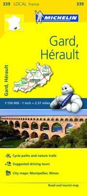
Gard and Hรฉrault dรฉpartments of France at 1:150,000 in Michelin’s Local Series, with highlighting for scenic routes, an index, a special panel with best sights and recommended driving tours, and street plans of Montpellier and Nรฎmes. The map extends from the Cรฉvennes National Park in the North to the Mediterranean and from Narbonne in the south-west to the Rhรดne Valley and the Camargue. Coverage includes Gorges of the Ardรจche, Orange, Arles and les Alpilles, Pont du Gard, Uzes, Alรจs, the Millaqu Viaduct, PRN des Grands Causses, Lodรจve, Bรฉziers, etc. PLEASE NOTE: our coverage image, provided by the publishers, does not take into account which areas along the edge of the map are blocked by the index and the additional features; the north-western corner is not included.Maps in Michelin’s Local Series of France have the same cartography (road network and place names shown on the maps) as the publishers’ Regional Series at 1;200,000 but enlarged here to 1:150,000 to provide greater clarity and larger, easier to read print size. Road network is presented in great detail, indicating width, motorway services and rest areas, dangerous or restricted entry roads, steep gradients, height and weight restrictions, etc. Scenic sections are highlighted. The maps also show selected cycle paths and nature trails. Railway lines are shown with stations and local airports are marked. Symbols indicate various places of interest, with additional star rating for best sights, based on the publishers’ Green Guides for French regions. Satellite-derived base with colouring for the forested areas and boundaries of national or regional parks shows the topography. In the mountainous regions the maps have bold, very effective relief shading, with a large number of names of peaks, passes, and other topographic features. The maps have latitude and longitude lines at 10’ intervals and are indexed. Map legend includes English.

Related Products:
 Drรดme – Vaucluse Michelin Local 332
 Nord Michelin Local 302
 Cher – Indre Michelin Local 323
 Doubs – Jura Michelin Local 321
 Niรฉvre – Yonne Michelin Local 319
 Gers – Lot-et-Garonne Michelin Local 336
 Loire – Rhรดne Michelin Local 327
 Gironde – Landes Michelin Local 335
 Haute-Saรดne – Vosges Michelin Local 314
 Bouches-du-Rhรดne – Var Michelin Local 340
 Aude – Pyrรฉnรฉes-Orientales Michelin Local 344
 Lot – Tarn-et-Garonne Michelin Local 337
 Isere – Savoie Michelin Local 333
 Corrรจze – Dordogne Michelin Local 329
 Pas-de-Calais – Somme Michelin Local 301
 Ariege – Haute-Garonne Michelin Local 343
 Allier – Puy-de-Dome Michelin Local 326
 Calvados – Manche Michelin Local 303
 Aisne – Ardennes – Marne Michelin Local 306
 Aveyron – Tarn Michelin Local 338
 Aube – Haute-Marne Michelin Local 313
 Eure – Seine-Maritime Michelin Local 304
 Eure-et-Loir – Paris – Yvelines Michelin Local 311
 Essonne – Paris – Seine-et-Marne Michelin Local 312
 Mayenne – Orne – Sarthe Michelin Local 310
 Creuse – Haute-Vienne Michelin Local 325
 Finistere – Morbihan Michelin Local 308
 Ardรจche – Haute-Loire Michelin Local 331
 Loire-Atlantique – Vendรฉe Michelin Local 316
 Meuse – Meurthe-et-Moselle Michelin Local 307
 Cantal – Lozรจre Michelin Local 330
 Loiret – Loir-et-Cher Michelin Local 318
 Cotes-d`Armor – Ille-et-Vilaine Michelin Local 309
 Cรดte-d`Or – Saรดne-et-Loire Michelin Local 320
 Alpes-Maritimes Michelin Local 341
 Indre-et-Loire – Maine-et-Loire Michelin Local 317
 Bas-Rhin – Haut-Rhin – Territoire de Belfort Michelin Local 315
 Charente – Charente-Maritime Michelin Local 324
 Ain – Haute-Savoie Michelin Local 328
 Hautes-Pyrรฉnรฉes – Pyrรฉnรฉes Atlantiques Michelin Local 342