Disclosure : This site contains affiliate links to products. We may receive a commission for purchases made through these links.
Ganesh Himal – Paldor Base Camp
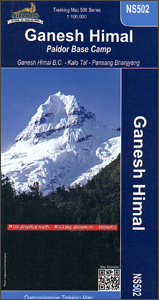
Ganesh Himal region of Nepal at 1:100,000 on a map from Nepa Maps highlighting numerous trekking routes, including treks to the Ganesh Himal (Yangra) and the Paldor (Bhrange) Base Camps. Coverage extends from south of Trisuli Bazar and Nuwakot northwards to the Siyar Khola Valley, and east to the Rasuwagadhi crossing to Tibet. Contour lines are at 40m intervals. Latitude and longitude are shown by margin ticks at 2’30″ intervals. The index list places, peaks, passes and lakes. On the inside cover are stage-by-stage distances and timings for the main route to the Ganesh Himal BC.PLEASE NOTE: the same area is also covered by the Ruby Valley Trek map which has more prominent highlighting for numerous routes in its central part, including the Ganesh Himal Cultural Trek, Ganesh Himal Hot Springs Trek, Kunda Trek, etc,Titles in this Nepa Maps series have cartography is based on the country’s topographic survey, with contours usually at 40m or 50m intervals, enhanced by relief shading, colouring and graphics to show various features of the terrain, including glaciers, forested or cultivated areas, etc. Numerous peaks, with additional spot heights, plus names of glaciers and mountain ranges are prominently shown. The network of rivers, streams and lakes is shown in great detail, with many smaller rivers and lakes named. Overprint highlights main trekking routes and numerous local trails, with symbols indicating various places of interest and tourist facilities. Most maps are indexed and include additional information such as route profiles, glossaries, etc. All the information is in English and heights are given in metres.To see other titles in this series please click in the series link.

Related Products:
 Everest Base Camp & Gokyo – Three Passes 50K
 Tenzing-Hillary Trek – Jiri to Everest Base Camp
 Annapurna Base Camp
 Ruby Valley Trek
 Manaslu & Ganesh Himals Great Himalaya Trail Map
 Makalu Base Camp
 Trekking around Ganesh Himal
 Ganesh Himal 2885-09
 Everest: Jiri to Everest Base Camp
 North Annapurna Base Camp
 Damodar Himal
 Dolpo & Mugu – Phoksumdo – Chharka Bhot – Kanjirowa Himal Great Himalaya Trail Map
 Nepal`s Far West – Api & Saipal Himal – Khaptad & Rapa NP – Humla Great Himayala Trail Map
 Sikles Trek
 Shivapuri Nagarjun National Park
 Everest Base Camp NGS Adventure Map 3001
 Khumbu – Sagarmatha National Park
 Jumla/Rara – Saipal – Sisne Himal – Gorakh Himal
 Royal Trek
 Dolpo Circuit
 Chulus
 Pisang Peak
 Tatopani Trek
 Dhorpatan Hunting Reserve
 Ghorepani – Ghandruk
 Khumbu Himal Schneider Nepal Map 02
 Dudhkunda- Pikey Cultural Trail & Rejno Pass Trail (Jiri – Pikey – Everest)
 Nepal: Nepa Trekking and Hiking Maps
Island Peak (Imja Tse)
Mt Everest, Khumbu Himal, Rolwaling Himal, Khumbakarna Himal
Nepal: Nepa Trekking and Hiking Maps
Island Peak (Imja Tse)
Mt Everest, Khumbu Himal, Rolwaling Himal, Khumbakarna Himal
 Panch Pokhari
 Pokhara to Muktinath and Jomosom
 Everest: A Trekker`s Guide: Base Camp, Kala Patthar and other trekking routes in Nepal and Tibet
 Gosainkunda – Trek to Shiva`s Sacred Lake
 Langthang Himal West Alpenverein 0/10
 Langthang Himal East Alpenverein 0/11
 Around Annapurna (100K)
 Mera Peak
 Langtang & Helambu Great Himalaya Trail Map
 Lukla to Gokyo – Cho-La – Renjo-La – Nagpa-La