Disclosure : This site contains affiliate links to products. We may receive a commission for purchases made through these links.
Galapagos Islands – Quito & Guayaquil ITMB
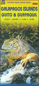
A map from ITMB conveniently combining coverage of the Galapagos Islands with street plans of Quito and Guayaquil plus road maps of the environs of both cities for those who wish to explore them on their way to or from the archipelago.On one side is a map at 1:380,000 of the Galapagos Islands with bold altitude colouring and contours at 50m intervals providing a vivid picture of their topography. Various peaks and other topographic features are named. Numerous locations across the whole archipelago are cross-referenced to photos and brief descriptions of the islands’ 13 most interesting animals and birds. The map shows ferry connections between the islands, access by air, and locations with tourist accommodation and other facilities.On the reverse is a large, indexed street plan of Quito at 1:12,500, orientated with the west at the top to provide a convenient coverage from the airport to the districts south of the Old City. Public transport options of El Trolle, Eco-Via and Metrobus-Q are very clearly marked, with the whole network also presented on a separate diagram. The plan also shows streets with or connected by stairways, providing a very useful indication of the city’s topography for those exploring the capital on foot. For drives main traffic arteries are highlighted, with clear presentation of access onto expressways, plus locations of petrol stations and car parks. Numerous places of interest are highlighted, including selected hotels, embassies, etc. Smaller panels on both sides present: a street plan of central Guayaquil at 1:10,000 with cartography similar to the plan of Quito; the Guayaquil region at 1:100,000; plus a Quito region road map extending north to Otavalo and Ibarra and south to Latacunga, so including the Mariscal Sucre International Airport, Cotopaxi, Cayambe, Sincholagua, etc.

Related Products:
 Quito & Central Ecuador ITMB
 Ecuador Borch
 Cayman Islands & Jamaica ITMB
 Sao Paulo & Brazil South Coast ITMB
 San Francisco & Northern California ITMB
 Okinawa & the Ryukyu Islands Periplus Travel Map
 Santiago & Chile North ITMB
 Galapagos Islands Explorer
 Caribbean Islands Western Half ITMB Travel Atlas
 The Rough Guide to Ecuador & the Galapagos (Travel Guide with Free eBook)
 Moon Quito (First Edition)
 Lonely Planet Ecuador and the Galapagos Islands
 Rome & Southern Italy ITMB
 Hanoi – Vietnam North ITMB
 Cairo & Nile Delta ITMB
 Mumbai / Bombay – India West Coast ITMB
 Ecuador – Galapagos Islands Reise Know-How
 Tehran & Northern Iran ITMB
 Bangkok & Thailand South ITMB
 Buenos Aires & Argentina North East ITMB
 Caribbean Islands East & South ITMB Travel Atlas
 Moon Ecuador & the Galapagos Islands (Seventh Edition)
 Paraguay – Bolivia South ITMB
 San Diego & USA South West Border ITMB
 Oahu, Honolulu & Big Island ITMB
 Tahiti & Cook Islands ITMB
 Zurich & Switzerland NW ITMB
 Falkland Islands Explorer
 Munich & Bavaria ITMB
 Polynesian Islands ITMB Travel Atlas
 Vancouver & Greater Vancouver ITMB
 Virgin Islands (US and British) ITMB
 Canary Islands ITMB
 Chicago & Lake Michigan ITMB
 Jakarta ITMB
 Manhattan & New York State ITMB
 Accra & Ghana South ITMB
 South Pacific Islands Nelles
 Washington DC & Eastern Corridor (Boston to DC) ITMB