Disclosure : This site contains affiliate links to products. We may receive a commission for purchases made through these links.
Fuentes Carrionas Massif Adrados Map PAPER
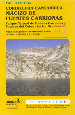
Fuentes Carrionas Massif, just south of the Picos de Europa, on a detailed hiking map from Adrados Ediciones combining coverage at 1:50,000 of the western part of Fuentes Carrionas and Fuentes del Cobre Natural Park with more detailed mapping at 1:25,000 of Peรฑa Prieta Massif.The main map at 1:50,000 has contours at 20m intervals with bold relief shading and altitude colouring. Numerous peaks and other topographical features are named. Hiking, mountain bike and ski trails are highlighted and symbols mark campsites, mountain shelters and cabins, viewpoints, climbing areas, tourist information centres, locations of petrol stations, etc. On the reverse the central part of the main map, the Peรฑa Prieta Massif is shown at 1:25,000 with the excellent cartography used in the publishers’ coverage of the Picos de Europa. Contours are at 10, intervals with additional graphic relief for exposed rocky faces. Both maps have a 1km UTM grid. Map legend includes English.To see the list of other hiking maps from Adrados Ediciones please click on the series link.

Related Products:
 Picos de Europa Western Massif: El Cornion Adrados Map PAPER
 Picos de Europa and Eastern Coast of Asturias Adrados Map
 Picos de Europa – Central and East Massifs: Los Urrieles and Andara Adrados Map PAPER
 Picos de Europa National Park – Anillo de Picos Adrados Map
 Spain: Adrados Hiking Maps
 Picos de Europa – Central and East Massifs: Los Urrieles and Andara Adrados Map WATERPROOF
 Somiedo Natural Park – Babia and North Laciana Adrados Map
 Cordillera Cantabrica – Asturias and the Surrounding Provinces Adrados Map
 Sierra de Gredos Adrados Map
Picos de Europa National Park Short and Long-Distance Trails
Sierra de Gredos Adrados Map
Picos de Europa National Park Short and Long-Distance Trails
 Muniellos: Fuentes del Narcea
 Posets and la Maladeta Massifs Adrados Map
 Massif des Bauges
Fuentes de Andalucia CNIG Topo 986
Massif des Bauges
Fuentes de Andalucia CNIG Topo 986
 Massif des Ecrins – Oisans – Champsaur IGN 75006
 Vercors Massif IGN 75001
 Chaรฎne des Puys – Massif du Sancy IGN 75015
 Massif de la Vanoise IGN 75003
 Chaine des Aravis – Massif des Bauges IGN 75032
 Fuentes de Onoro CNIG Topographic Map 525-I
Fuentes de Ebro CNIG Topo 384
Fuentes de Onoro CNIG Topographic Map 525-I
Fuentes de Ebro CNIG Topo 384
 Beaufortain – Massif du Mont Blanc IGN 75004
 Mont Blanc Massif IGC 4
Villarejo de Fuentes CNIG Topo 661
Mont Blanc Massif IGC 4
Villarejo de Fuentes CNIG Topo 661
 รcrins Massif National Park Didier Richard 05
 Picos de Europa National Park 3-Map and Guide Set CNIG ENGLISH
 Picos de Europa National Park 2-Map Set Editorial Alpina
 Picos de Europa National Park 3-Map and Guide Set CNIG SPANISH
Massif Central IGN Top200 204
Picos de Europa National Park 3-Map and Guide Set CNIG SPANISH
Massif Central IGN Top200 204
 Pyrรฉnรฉes Catalanes – Font-Romeu – Massif du Canigou IGN 75021
Massif des Vosges – Plaine d`Alsace IGN Top200 201
Las Fuentes CNIG Topo 767-4
Pyrรฉnรฉes Catalanes – Font-Romeu – Massif du Canigou IGN 75021
Massif des Vosges – Plaine d`Alsace IGN Top200 201
Las Fuentes CNIG Topo 767-4
 Sofia Street Atlas with Vitosha Massif
Villarejo de Fuentes CNIG Topo 661-1
Fuentes de Nava CNIG Topo 273-3
Sofia Street Atlas with Vitosha Massif
Villarejo de Fuentes CNIG Topo 661-1
Fuentes de Nava CNIG Topo 273-3
 Massif des Bauges Parc Naturel Rรฉgional IGN 83308
Toubkal Massif
Massif des Bauges Parc Naturel Rรฉgional IGN 83308
Toubkal Massif
 Massif de la Vanoise IGN Wall Map
 Picos de Europa Sunflower Landscape Guide
 Ecrins Massif Wall Map