Disclosure : This site contains affiliate links to products. We may receive a commission for purchases made through these links.
France: James Wyld`s Map of the French Provinces c.1844 MEDIUM
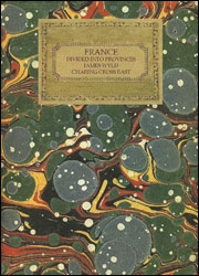
A cloth-backed reproduction (medium size) of a map of France published around 1818 by James Wyld, with colouring showing the division of the country into provinces which by then were already abolished in 1790 (reinstated during the Bourbon Restoration???) and replaced by the more familiar dรฉpartement system. The map will appeal to any visitors to France who may be puzzled by the still frequently used names such as Artois, Daufinรฉ, Guienne, Saintonge, etc. In some cases modern regions or dรฉpartements share names with the historic provinces and their borders cover roughly the same territory.The provinces are presented in different colours, with the network of rivers, graphics showing main mountain ranges, and road connections. Latitude and longitude lines are drawn at 1ยฐ intervals. The Bay of Biscay is annotated ‘called by the French Gulf of Gascony” (English Channel and the Straights of Dover do not get the same generous treatment!); Corsica is not included (Bourbons again?); another interesting feature is the linear scale of the map shown as: Common French Leagues 25 to a degree, Great French Leagues 20 to a degree, plus English Statute Miles 69ยฝ to a degree.This reproduction was taken from what used to be called a ‘cloth-dissected” map, made when the map itself was cut into sections and each section then individually pasted onto an overall cloth backing for the whole map. In this version the whole map is backed onto cloth in one piece but the gaps between the sections have been reproduced in the printing to preserve the style and the feeling of the original. Each individual cloth-backed map is sold folded in a colourful case covered with a unique design marbled paper ‘“ no two cases are identical.PLEASE NOTE: to see the list of all the titles in this series from the Old Folding Maps please click on the series link.


