Disclosure : This site contains affiliate links to products. We may receive a commission for purchases made through these links.
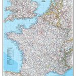
France, Belgium and Netherlands NGS Executive Wall Map ENCAPSULATED
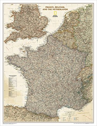
France, Belgium and Netherlands at 1:1,953,000 on a small wall map, 59 x 76cm (23″x30″ approx) – encapsulated version, from the National Geographic Society in their highly successful Executive style resembling antique maps in colouring, with muted hues for the land and the surrounding seas in shades of beige.The map has relief shading to show the topography, with international borders highlighted in different colours. Names of many geographical (Cรฉvennes), or historical (Bourbonais) regions are shown in France, with boundaries of the current administrative (Brittany, etc) regions – their names are indicated by numbers cross-referenced to lists of administrative regions of France and Belgium and the provinces of the Netherlands. Within Belgium and the Netherlands local names of town are used (Antwerpen, Den Haag) with English equivalents also shown. Coverage includes most of England and Wales, extending north beyond Lancaster and Harrogate. Latitude and longitude lines are drawn at intervals of 1ยฐ.PLEASE NOTE: this map is also available on paper without the encapsulation.LAMINATED and ENCAPSULATED WALL MAPS:- LAMINATED wall maps have a thin layer of plastic usually applied to the printed side only. They can be written on with suitable marker pens without any damage to the map but, unless laminated on both sides, they are not damp-proof.- ENCAPSULATED wall maps are sealed between two sheets of plastic. They are more rigid and heavier than laminated maps of the same size. They are damp-proof and do not crinkle in humid conditions. Encapsulation gives the map a shiny surface, similar to being displayed behind glass.- PLEASE NOTE: many publishers and retailers often use these two terms interchangeably. Our map titles and descriptions follow the definitions provided above.

Related Products:
 France, Belgium and Netherlands NGS Classic Wall Map LAMINATED
 France, Belgium and Netherlands NGS Executive Wall Map PAPER
 Ireland NGS Executive Wall Map ENCAPSULATED
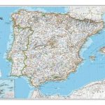
 Spain and Portugal NGS Executive Wall Map ENCAPSULATED
 Italy NGS Executive Wall Map ENCAPSULATED
 Mexico NGS Executive Wall Map ENCAPSULATED
 Brazil NGS Executive Wall Map ENCAPSULATED
 North America NGS Executive Wall Map ENCAPSULATED
Scotland NGS Executive Wall Map ENCAPSULATED
North America NGS Executive Wall Map ENCAPSULATED
Scotland NGS Executive Wall Map ENCAPSULATED
 France, Belgium and Netherlands NGS Classic Wall Map PAPER
 China NGS Executive Wall Map ENCAPSULATED
 South America NGS Executive Wall Map ENCAPSULATED
 World Executive Ray & Co Wall Map ENCAPSULATED
 England and Wales NGS Executive Wall Map ENCAPSULATED
 Germany NGS Executive Wall Map ENCAPSULATED
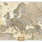 Europe NGS Executive Wall Map ENCAPSULATED
 Japan NGS Executive Wall Map ENCAPSULATED
 Britain and Ireland NGS Executive Wall Map ENCAPSULATED
 Australia NGS Executive Wall Map ENCAPSULATED
 Asia NGS Executive Wall Map ENCAPSULATED
 United States NGS Executive Wall Map ENCAPSULATED
 France IGN Administrative Wall Map
 Ireland NGS Classic Wall Map ENCAPSULATED
 Iraq NGS Classic Wall Map ENCAPSULATED
 Spain and Portugal NGS Classic Wall Map ENCAPSULATED
 Africa NGS Executive Wall Map ENCAPSULATED
 Italy NGS Classic Wall Map ENCAPSULATED
 World Rand McNally Classic Wall Map ENCAPSULATED
 World Rand McNally Signature Wall Map ENCAPSULATED
 World NGS Executive Wall Map ENCAPSULATED
 California NGS Wall Map ENCAPSULATED
 USA Michelin Political Wall Map ENCAPSULATED
 China NGS Classic Wall Map ENCAPSULATED
 Britain and Ireland NGS Classic Wall Map ENCAPSULATED
 Caribbean NGS Classic Wall Map ENCAPSULATED
 World NGS Executive Pacific-Centered Wall Map ENCAPSULATED
 Mexico NGS Classic Wall Map ENCAPSULATED
 British Isles Map Marketing Route Planning Wall Map ENCAPSULATED
 World NGS Executive Wall Map LARGE ENCAPSULATED
England and Wales NGS Classic Wall Map ENCAPSULATED
World NGS Executive Wall Map LARGE ENCAPSULATED
England and Wales NGS Classic Wall Map ENCAPSULATED