Disclosure : This site contains affiliate links to products. We may receive a commission for purchases made through these links.
Four Counties Ring & Caldon Canal Heron Map
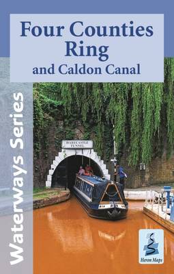
A tourist map at 1:50,000 scale of the Four Counties Ring and Caldon Canal, including the Shropshire Union Canal from Beeston to Autherley Junction, parts of the Staffordshire and Worcestershire Canal, Trent and Mersey Canal, and the Middlewich Branch, with detailed town plans at 1:12,500 of Brewood, Market Drayton, Audlem, Nantwich, Middlewich, Kidsgrove, Etruria and Hanley, Stone and Penkridge.The map, suitable for both waterways and leisure users, includes navigation and historical information, visitor moorings, marinas and boatyards, boat hire centres, facilities for the boat user, sailing and boat clubs, shops, post offices and distance markers. Information for the tourist includes tourist information centres, places of interest, pubs, nature reserves, parks, churches, national cycle routes, long distance paths, public toilets and caravan and camp sites.To see the list of other titles in this series, please click on the series link.

Related Products:
 Shropshire Union Canal, incl. Middlewich Branch & up to Gr. Haywood Junction Heron Map
 Warwickshire Ring, Ashby-de-la-Zouch Canal & up to Fradley Junction Heron Map
 Llangollen and Montgomery Canal Heron Maps
 Grand Union Canal – Braunston to Kings Langley Heron Map
 Stourport Ring & Droitwich Ring Heron Map
 Birmingham Canal Navigations Heron Map
 Oxford Canal: Oxford to Hawkesbury Junction & to Coventry Basin Heron Map
 Avon Ring and Droitwich Ring Heron Map
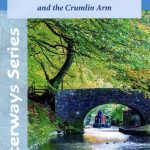 Monmouthshire and Brecon Canal – and Crumlin Arm Heron Map
 Grand Union Canal: Stoke Bruerne to Leicester, River Soar & Erewash Canal Heron Map
 Grand Union Canal: Braunston to Kings Langley Heron Map
 Grand Union Canal – Birmingham to Milton Keynes Heron Maps
 Kennet & Avon Canal – River Avon Heron Map
 Leeds and Liverpool Canal – Liverpool to Keighley Heron Map
 River Thames and the Thames Path Heron Maps
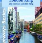 Grand Union Canal: Milton Keynes to London, with the London & East London Rings Heron Map
 Four Counties Ring Pearson`s Canal Companion
 River Thames & Thames Path Heron Map
Great Britain: Heron Canal Maps
River Thames & Thames Path Heron Map
Great Britain: Heron Canal Maps
 Cheshire Ring and South Pennine Ring Pearson`s Canal Companion
 Leeds & Liverpool Canal – Foulridge to Leeds; Aire & Calder to Knottingley; Calder & Hebble Heron Map
 Grand Union Canal – Milton Keynes to London and the London Ring Heron Maps
 South Midlands & Warwickshire Ring Pearson`s Canal Companion
 Canal du Midi Cycle Route: Toulouse to the Mediterranean – Canal de la Robine (265km) Bikeline Map/Guide
 Pearson`s Canal Companion – Severn and Avon: Mid-Worcestershire Ring and Cotswold Canals
 Four Counties & the Welsh Canals Collins Nicholson Waterways Guide 4
 Kennet & Avon Canal and River Thames Pearson`s Canal Companion
 Mayo and Sligo Xploreit Counties Map
 Cycling the Canal de la Garonne: From Bordeaux to Toulouse
 Canal du Midi Cycle Route Bikeline Map-Guide
 Canal du Midi
 Ems Cycle Route – Senne to North Sea – incl. Dortmund-Ems Canal Bikeline Map-Guide
 The Rhรดne to the Rhine Canal
 Alpi Carniche Orientali – Canal del Ferro – Nassfeld Tabacco 018
 The Kennet and Avon Canal: The Full Canal Walk and 20 Day Walks
 Northwich & Delamere Forest – Winsford & Middlewich OS Explorer Map 267 (paper)
 Leeds & Liverpool Pearson`s Canal Companion
 The Canal Boat Cafe: A Perfect Feel Good Romance
 Canal de l`Ourcq and the Canals of Paris
 Oxford, Grand Union and Upper Thames Pearson`s Canal Companion