Disclosure : This site contains affiliate links to products. We may receive a commission for purchases made through these links.
Four Corners Region Destination Map
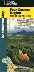
America’s famous Four Corners region, the only spot in USA where four states meet, presented by the National Geographic in their Destination Map series with highlighting for protected areas and tourist notes, plus on the reverse four separate thematic maps on different aspect of this fascinating region.Printed on light, waterproof and tear-resistant synthetic paper, the map is centred on the Four Corners Monument, the meeting point of Colorado, Utah, Arizona and New Mexico. Coverage extends north to the Black Canyon of the Gunnison NP, east to the Sangre de Cristo Mountains, west to the Gran Canyon Village and south beyond the Highway 40 linking Santa Fe, Albuquerque and Flagstaff.Relief shading provides an excellent picture of the terrain; various types of protected areas (national/state parks, forests, etc) and the region’s numerous Indian Reservations are indicated by the colour of their borders. Road network is graded in six types, including unpaved roads. Symbols highlight various places of interest, many annotated with brief notes. The map has latitude and longitude lines at 1ยฐ intervals.The reverse side has four separate maps, each designed to present a different aspect of the area: archaeology, outdoor recreation, water and geology, plus art, music and culture. There is also a table showing facilities in the national parks, plus travel tips.

Related Products:
 Indian Country – the Four Corners Region AZ/CO/NM/UT
 Alaska`s Inside Passage NGS Destination Map
 Canadian Rockies NGS Destination Map
 Cascades Destination Map
 Sierra Nevada Destination Map
 Blue Ridge Parkway NC/VA Destination Map
 Texas Hill Country Destination Map
 New York`s Finger Lakes Destination Map
 The Caribbean Destination Map
 USA: National Geographic Destination Maps of Popular Scenic Regions
 Gold Coast and Region Hema
 Colorado Plateau – Canyonlands – Southern Rocky Mountains
 Argentina ACA Regional Zone 6 – Region Buenos Aires
 Argentina ACA Regional Zone 4 – Region Centro
 Canberra and Region Hema
 Cairns and Region Hema
 Argentina ACA Regional Zone 3 – Region Litoral
 Argentina ACA Regional Zone 2 – Region Cuyo y Norte
 Wisconsin`s Door Peninsula Destination Map
 Argentina ACA Regional Zone 5 – Region Cuyo (incl. Aconcagua – Mendoza – San Luรญs)
 Brabant Provinces (Flemish and Wallon) and Brussels Region
 Adelaide and Region Hema
Sydney and Region Hema
Adelaide and Region Hema
Sydney and Region Hema
 Kiev Administrative Region
Zaporizhzhia Administrative Region
Zhytomyr Administrative Region
Ternopil Administrative Region
Lviv Administrative Region
Dnipropetrovsk Administrative Region
Mikolayiv Administrative Region
Rivne Administrative Region
Vinnytsia Administrative Region
Chernihiv Administrative Region
Kharkiv Administrative Region
Cherkasy Administrative Region
Kirovohrad Administrative Region
Kherson Administrative Region
Chernivtsi Administrative Region
Sumy Administrative Region
Kiev Administrative Region
Zaporizhzhia Administrative Region
Zhytomyr Administrative Region
Ternopil Administrative Region
Lviv Administrative Region
Dnipropetrovsk Administrative Region
Mikolayiv Administrative Region
Rivne Administrative Region
Vinnytsia Administrative Region
Chernihiv Administrative Region
Kharkiv Administrative Region
Cherkasy Administrative Region
Kirovohrad Administrative Region
Kherson Administrative Region
Chernivtsi Administrative Region
Sumy Administrative Region