Disclosure : This site contains affiliate links to products. We may receive a commission for purchases made through these links.
Finger Lakes, NY Qickmap
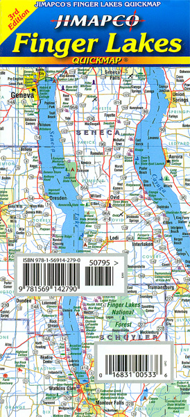
Fingers Lakes region in the western part of New York State on a laminated, waterproof and tear-resistant road map at 1:316,800 from Jimapco, with on the reverse 14 more detailed maps of main towns. The index also lists places of interest and various local facilities.On one side is the map showing the region’s road and rail networks and prominently highlighting state parks and other protected areas. Symbols indicate various places of interest including campgrounds, recreational areas, historic landmarks, golf courses, wineries, etc. Coverage extends from Lake Ontario to the state border and from Syracuse and Binghamton westward beyond Rochester to Batavia. The map has no geographical coordinates. The index is on the reverse and includes lists of campgrounds, wineries, golf courses, cultural attractions, etc.The reverse side also includes more detailed maps of the regions’ main towns: Auburn, Canandaigua, Cortland ‘“ Homer, Dansville, Geneseo, Geneva, Hammondsport, Ithaca, Newark, Palmyra, Penn Yan, Skaneateles, Watkins Glen ‘“ Montour Falls and Waterloo.

Related Products:
 Hudson Valley NY Qickmap
 The Poconos, PA Qickmap
 New York`s Finger Lakes Destination Map
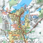
 Puget Sound and Greater Seattle, WA
 New York State Recreational Atlas & Gazetteer
 Macedonia Wineries Map
 California Benchmark Road & Recreation Atlas
 Michigan Recreational Atlas & Gazetteer
 25 Bike Rides in the Finger Lakes
 Adirondacks NY
 Pennsylvania Recreation Atlas
 Washington State Benchmark Recreation Map
 New Hampshire – Vermont DeLorme Atlas & Gazetteer
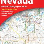 Nevada Recreational Atlas & Gazetteer
 Coast Around Lisbon Turinta
 Mississippi Recreational Atlas & Gazetteer
 South Carolina Recreational Atlas & Gazetteer
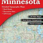 Minnesota Recreational Atlas & Gazetteer
 Oregon & Northern California Coast Road & Recreation Map
 Great Lakes Michelin Zoom 173
 Adirondack NY Qickmap
 Mallorca: Cala Millor – Cala Bona – Sa Costa des Pins – S’illot – Sa Coma
 Utah Benchmark Recreation Map
Mallorca – Serra de Tramuntana
Utah Benchmark Recreation Map
Mallorca – Serra de Tramuntana
 Monti Iblei – South-Eastern Sicily Global Map Tourist Map
 Great Lakes USA 03 Hallwag Road Map
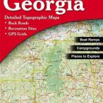 Georgia Recreational Atlas & Gazetteer
 Alabama Recreational Atlas & Gazetteer
 O`ahu Island and Honolulu
 Oregon Benchmark Recreational Map
 Connecticut & Rhode Island DeLorme Atlas & Gazetteer
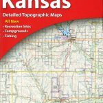 Kansas DeLorme Atlas & Gazetteer
 Victoria Hema
Mallorca – Alcudia – Playa de Muro – C`an Picafort
Victoria Hema
Mallorca – Alcudia – Playa de Muro – C`an Picafort
 California Wine Map Global Graphics
 Costa Rica Borch
 Cape Town Map Studio Pocket Map
 Carpathians Kartografija Tourist Map ENGLISH
Mallorca – Pollenca – Port de Pollenca – Alcudia – Port d`Alcudia – Can Picafort
Carpathians Kartografija Tourist Map ENGLISH
Mallorca – Pollenca – Port de Pollenca – Alcudia – Port d`Alcudia – Can Picafort