Disclosure : This site contains affiliate links to products. We may receive a commission for purchases made through these links.
Fermanagh Lakelands & Tyrone Cycle Map 50 Sustrans
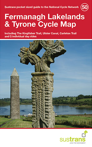
This is in the series of pocket sized, folded maps to the National Cycle Network which include clearly mapped on-road and traffic-free paths, easy to read contours and detailed town insets. Published by Sustrans. 1:110,000 scale; folded 155mm x 99mm; flat 792mm x 630mm. Fermanagh Lakelands & Tyrone Cycle Map (50). Including The Kingfisher Trail, Ulster Canal, Carleton Trail & 5 individual day rides.

Related Products:
 The Causeway Coast & Glens Cycle Map 52 Sustrans
 West Yorkshire Sustrans Cycle Map 29
 Dorset Downs Sustrans Cycle Map 5
 Devon North Sustrans Cycle Map 3 – Including the Tarka Trail
 Glasgow – Stirling & the Clyde Sustrans Cycle Map 41
 Belfast, Down & Armagh Cycle Map
 Derry ~ Londonderry & The North West Cycle Map 51 sustrans
 Norfolk Sustrans Cycle Map 19
 South East Wales – Taff Trail – Celtic Trail – Lon Las Cymru – 3 Parks Trail Sustrans Cycle Map 12
 North West Ulster: Londonderry, Donegal, Fermanagh and Tyrone Pevsner Architectural Guide
 Tyne & Wear Sustrans Cycle Map 34 – incl. the Sea to Sea, Hadrian`s Cycleway, Reivers Route
 Suffolk – Ipswich – Bury St Edmunds – Felixstowe – Suffolk Coast Cycle Route Sustrans Cycle Map 18
 Mid-Wales South Sustrans Cycle Map 14
 Merseyside & Manchester – Pennine Cycleway – The Trans Pennine Trail Sustrans Cycle Map 25
 North Wales – Lon Eifion – Lon Las Cefni – North Wales Coast Route Sustrans Cycle Map 24
 Donegal – Fermanagh – Tyrone OSI Discovery 11
 The Bay Cycle Way Sustrans Cycle Route Map
 Mid-Wales North Sustrans Cycle Map 23
 The Peak District Sustrans Cycle Map 26 – Trans Pennine Trail – Tissington Trail – High Peak Trail
 Devon South Sustrans Cycle Map 2
 Donegal – Fermanagh – Leitrim – Sligo OSI Discovery 16
Kent 110K Sustrans Cycle Map No. 8
Donegal – Fermanagh – Leitrim – Sligo OSI Discovery 16
Kent 110K Sustrans Cycle Map No. 8
 East Midlands 110K Sustrans Cycle Map No. 21
 Pennine Cycleway South Sustrans Cycle Route Map
 Celtic Trail Sustrans Cycle Route Map
 Hampshire & Isle of Wight Sustrans Cycle Map 6
 Warwickshire & South Midlands 110K Sustrans Cycle Map No. 16
County Durham & North Yorkshire Sustrans Cycle Map 32
Cornwall Sustrans Cycle Map 1 – The Camel Trail – Clay Trails – Mineral Tramways
Warwickshire & South Midlands 110K Sustrans Cycle Map No. 16
County Durham & North Yorkshire Sustrans Cycle Map 32
Cornwall Sustrans Cycle Map 1 – The Camel Trail – Clay Trails – Mineral Tramways
 South West Wales 110K Sustrans Cycle Map No. 13
Yorkshire Wolds, York & the Humber Sustrans Cycle Map 28
South West Wales 110K Sustrans Cycle Map No. 13
Yorkshire Wolds, York & the Humber Sustrans Cycle Map 28
 Aberdeenshire 110K Sustrans Cycle Map No. 45
 Lanarkshire & Scottish Borders 110K Sustrans Cycle Map No. 38
London Sustrans Cycle Map 53
Lanarkshire & Scottish Borders 110K Sustrans Cycle Map No. 38
London Sustrans Cycle Map 53
 Central Sussex & South Surrey Sustrans Cycle Map 7
 Oban, Kintyre & the Trossachs 110K Sustrans Cycle Map No. 42
 West Dumfries & Galloway 110K Sustrans Cycle Map No. 36
 North Cumbria & Dumfries 110K Sustrans Cycle Map No. 35
 Lincolnshire and Wolds Sustrans Cycle Map 27
 Perth, Callander & Pitlochry 110K Sustrans Cycle Map No. 43