Disclosure : This site contains affiliate links to products. We may receive a commission for purchases made through these links.
Farther India MEDIUM
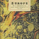
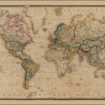
Europe in 1884 on a cloth-backed reproduction of a map published by Edward Stanford, presenting the continent at the height of its great empires: imperial Russia with Finland and much of Poland, united Germany including Alsace and part of Lorraine, the Austro-Hungarian Empire (although already post the Compromise, still shown here as one country) with north-western Balkans, and the Ottomans still with Albania and much of the present-day Greece. Hachures indicating the mountain ranges are in most places printed very faintly so names of towns and numerous geographical region marked on the map are easy to read. The map also has an unusually large number of names of smaller rivers. Latitude and longitude lines are drawn at 5ยฐ intervals.Each individual cloth-backed map is sold folded in a colourful case covered with a unique design marbled paper ‘“ no two cases are identical.PLEASE NOTE: this title is also available as a wall map in two different sizes in the ‘Stanfords Classics Collection of Historical Maps”. To see the list of all the titles in this series from the Old Folding Maps please click on the series link.

Related Products:
 Farther India
 Europe: An Accurate Map of Europe in 1755 MEDIUM
India c. 1835 MEDIUM
Europe: An Accurate Map of Europe in 1755 MEDIUM
India c. 1835 MEDIUM
 Europe: Stanfords Map of Europe in 1884 SMALL
 France: James Wyld`s Map of the French Provinces c.1844 MEDIUM
 Spain and Portugal 1842 SMALL
Spain and Portugal 1885 SMALL
World Regions c. 1890 MEDIUM
Spain and Portugal 1842 SMALL
Spain and Portugal 1885 SMALL
World Regions c. 1890 MEDIUM
 Palestine or the Holy Land c.1818 MEDIUM
 Australian Colonies and New Zealand c.1874 MEDIUM
 World on Mercator`s Projection by James Wyld c.1861 MEDIUM
Russia c. 1895 MEDIUM
North Polar Chart 1902 MEDIUM
World on Mercator`s Projection by James Wyld c.1861 MEDIUM
Russia c. 1895 MEDIUM
North Polar Chart 1902 MEDIUM
 India c.1838 MEDIUM
 London: Lewis` Topographical Dictionary Plan 1840 MEDIUM
 Africa: Gall & Inglis Map c.1854 MEDIUM
 World: Stanfords Pacific Centred Map of the World 1884 SMALL
Paris: Plan de Paris c.1818 MEDIUM
World: Stanfords Pacific Centred Map of the World 1884 SMALL
Paris: Plan de Paris c.1818 MEDIUM
 Paris: Plan de Paris et ses Fortifications c.1844 MEDIUM
 Europe: Cruchley`s New Map of Europe c.1860 MEDIUM
 Bristol: Bartholomew`s Street Plan c.1870 MEDIUM
London: Rocque London c. 1741-5 MEDIUM
Bristol: Bartholomew`s Street Plan c.1870 MEDIUM
London: Rocque London c. 1741-5 MEDIUM
 France: Cruchley`s Map for Schools and Families c.1842 MEDIUM
 Asia: Stanfords Map of Asia in 1884 SMALL
 London: Urbium Londini et West Monasterii c.1736 MEDIUM
 England and Wales: Brookes` Travelling Companion Map MEDIUM
 Italy: Stanfords Map of Italy 1859 MEDIUM
 Ireland: A New Map by William Faden c.1797 MEDIUM
 The World On Mercators Projection C.1861
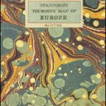 Europe: Stanfords Tourist/Railways Map of Europe 1928 SMALL
 Scotland c.1714 MEDIUM
 London: Robert Sayer`s London Directory Map 1792 MEDIUM
London: Vicinity of London c.1847 MEDIUM
London: Robert Sayer`s London Directory Map 1792 MEDIUM
London: Vicinity of London c.1847 MEDIUM
 London: Daniel Paterson`s 24 Miles Round London with Seats of Gentry and Nobility c.1791 MEDIUM
 London: Cruchley`s 12 Miles Round London c.1826 MEDIUM
 China c. May, 1828 MEDIUM
British Isles Geological MEDIUM
China c. May, 1828 MEDIUM
British Isles Geological MEDIUM
 London: A New Map of London by Robert Laurie & James Whittle c.1800 MEDIUM
 Eastern Hemisphere: Stanfords Map from 1877 SMALL
Europe: Cruchley`s New Map of Europe c.1860 SMALL
Eastern Hemisphere: Stanfords Map from 1877 SMALL
Europe: Cruchley`s New Map of Europe c.1860 SMALL