Disclosure : This site contains affiliate links to products. We may receive a commission for purchases made through these links.
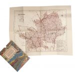
Exeter and the Lower Exe Valley 1888
Exeter and the Lower Exe Valley 1888 in a series of reproductions of Ordnance Survey’s famous “Inch to the Mile” maps published in the Alan Godfrey Editions to provide a historical record of England and Wales in the second half of 19th and early 20th century.The map is centred on Exeter, stretching from Yeoford and Tedburn St Mary eastwards to Whimple, and from Bradninch southwards to Exminster. Other locations include Alphington, Aylesbeare, Brampford Speke, Bridford, Broad Clyst, Cadbury, Clyst Honiton, Clyst Hydon, Clyst St George, Clyst St Lawrence, Crediton, Doddiscombsleigh, Dunchideock, Dunsford, Farringdon, Holcombe Burnell, Huxham, Nether Axe, Newton St Cyres, Pinhoe, Plymtree, Poltimore, Rockbeare, Sandford, Shillingford, Shobrooke, Silverton, Sowton, Stockleigh Pomeroy, Stoke Canon, Talaton, Thorverton, Topsham, Up Exe, Upton Hellions, Upton Pyne, Whitestone and Woodbury. On the reverse is an extract from Devon Sheet 69.11, showing the village of Whimple in more detail, complete with directoryAbout the Alan Godfrey Editions of the OS Inch to the Mile Maps: the maps provide an invaluable overview of a wider area, typically 18 x 12 miles (29 x 19 kms approx.), and offer historical mapping for small towns and villages not covered by the more detailed series for which the Godfrey Editions are better known. On the reverse all the maps have historical notes and most titles also include a more detailed, large scale map of a small town or a village in the area.To see other titles in this series please click on the series link.

Related Products:
 Penzance and St Ives Bay 1888
Exeter 1888 – 80.06a Colour Edition
The Solent 1888
North Chilterns 1888
North West Surrey 1888
Upper Exe Valley 1907
Isle of Thanet 1893 – 274
Redesdale 1866
Colne Valley and Braintree 1887
East Surrey and Mole Valley 1885
Beachy Head, Newhaven and Eastbourne 1880 – 1903
Roding Valley and Epping Forest 1886
Penzance and St Ives Bay 1888
Exeter 1888 – 80.06a Colour Edition
The Solent 1888
North Chilterns 1888
North West Surrey 1888
Upper Exe Valley 1907
Isle of Thanet 1893 – 274
Redesdale 1866
Colne Valley and Braintree 1887
East Surrey and Mole Valley 1885
Beachy Head, Newhaven and Eastbourne 1880 – 1903
Roding Valley and Epping Forest 1886
 Great Britain: Godfrey Editions of Historical Ordnance Survey Inch to a Mile Maps of England & Wales
Kielder 1866
Norham & Berwick 1864 – 1
The Cheviot 1901-13 – 5
Isles of Scilly 1896
Formby, Crosby and District 1896
Hertford and St Albans 1898
Ravenglass and Sellafield 1875
Weston-super-Mare & Highbridge 1897 – 279
Holy Island & District 1863 – 4
Dartmoor 1908
Exeter 1904 – 80.06b
Rothbury Forest 1866-1873
Holy Island & Seahouses 1898 – 4.1 Coloured Edition
Foulness and Mersea 1904
Kirkby Lonsdale and District 1870
Sevenoaks and Tonbridge 1893
Fareham, Hambledon and Havant 1894
Tunbridge Wells and Ashdown Forest 1894
North Kent Coast 1878
Selsey Bill, Bognor and Worthing 1901
Longtown, Bewcastle and District 1902
Horsham, Crawley and St Leonards`s Forest 1901
East Radnorshire 1908
North Dartmoor and Mid-Devon 1887
South Lancashire Coalfield 1907
Liverpool & The Wirral 1904 – 96
Windsor Forest and District 1887
Great Britain: Godfrey Editions of Historical Ordnance Survey Inch to a Mile Maps of England & Wales
Kielder 1866
Norham & Berwick 1864 – 1
The Cheviot 1901-13 – 5
Isles of Scilly 1896
Formby, Crosby and District 1896
Hertford and St Albans 1898
Ravenglass and Sellafield 1875
Weston-super-Mare & Highbridge 1897 – 279
Holy Island & District 1863 – 4
Dartmoor 1908
Exeter 1904 – 80.06b
Rothbury Forest 1866-1873
Holy Island & Seahouses 1898 – 4.1 Coloured Edition
Foulness and Mersea 1904
Kirkby Lonsdale and District 1870
Sevenoaks and Tonbridge 1893
Fareham, Hambledon and Havant 1894
Tunbridge Wells and Ashdown Forest 1894
North Kent Coast 1878
Selsey Bill, Bognor and Worthing 1901
Longtown, Bewcastle and District 1902
Horsham, Crawley and St Leonards`s Forest 1901
East Radnorshire 1908
North Dartmoor and Mid-Devon 1887
South Lancashire Coalfield 1907
Liverpool & The Wirral 1904 – 96
Windsor Forest and District 1887