Disclosure : This site contains affiliate links to products. We may receive a commission for purchases made through these links.
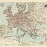
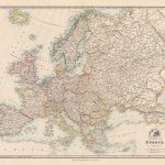
Europe: Stanfords Tourist/Railways Map of Europe 1928 SMALL
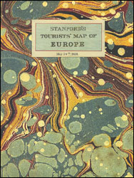
Cloth-backed reproduction of a Tourist Map of Europe published by Stanford’s Geographical Establishment in May 1928, showing country borders in contrasting colours and the network on main and subsidiary railway lines. Coverage includes the southern coastline of the Mediterranean and extends to the eastern coast of the Black Sea, but in the north only the southern part of Scandinavia is included.The map shows Europe with its post-Versailles borders; British Isles have the same red border for both GB and the whole of Ireland, but acknowledging the existence of the ‘Irish Free State”. International borders along the southern and the eastern Mediterranean indicate colonial or mandated possessions. Within all the countries map shows main and subsidiary railway lines, displaying the great contrast between the extensive networks within Germany, most of England or northern France and the less densely covered eastern and south-eastern parts of Europe. Within Russia the ‘straight-as-the-Tsar’s-ruler-but-with-two-kinks-for-his-fingers” line linking St. Petersburg with Moscow catches one’s eye. Latitude and longitude lines are drawn at 2ยฐ intervals. Each individual map is sold folded in a colourful case covered with a unique design marbled paper ‘“ no two cases are identical.PLEASE NOTE: this title is also available in two sizes as a wall map in the ‘Stanfords Classics Collection of Historical Maps”. To see the full list of other titles in this fascinating series of cloth-backed maps from the Old Folding Maps company please click on the series link.

Related Products:
 Europe: An Accurate Map of Europe in 1755 MEDIUM
 Stanfords Tourist Map of Europe (1928) 40×50 Canvas Print
 Europe: Stanfords Map of Europe in 1884 SMALL
 Europe: Cruchley`s New Map of Europe c.1860 SMALL
Europe: Cruchley`s New Map of Europe c.1860 MEDIUM
Europe: Cruchley`s New Map of Europe c.1860 SMALL
Europe: Cruchley`s New Map of Europe c.1860 MEDIUM
 Europe Railways + Ferries F&B Wall Map
 Europe K+F Railways Map
 Europe Railways + Ferries F&B
 Eastern Hemisphere: Stanfords Map from 1877 SMALL
 World: Stanfords Pacific Centred Map of the World 1884 SMALL
 Balkans – South-East Europe F&B
 Italy: Stanfords Map of Italy 1859 MEDIUM
 Italy: Stanfords Map of Italy 1859 SMALL
 World on Mercator`s Projection by James Wyld c.1861 MEDIUM
 The World On Mercators Projection C.1861
 Western Hemisphere: Stanfords Map from 1877 SMALL
 Asia: Stanfords Map of Asia in 1884 SMALL
 Palestine or the Holy Land c.1818 MEDIUM
 Central Europe F&B Road Atlas
Palestine or the Holy Land c.1818 SMALL
Central Europe F&B Road Atlas
Palestine or the Holy Land c.1818 SMALL
 British Isles: Stanfords Map of the British Isles c.1859 SMALL
 Cruchley`s London 1832
 Europe F&B Long Distance Pilgrimage Trails Map
 Europe Wine Map
 Europe Physical F&B
 Europe Editions Benoit Wine Wall Map
 Europe – Middle East – Central Asia F&B
 Stanfords Western Hemisphere Wall Map c.1877 LARGE
 Europe Eastern ITMB Railway & Road
 Spain and Portugal 1842 SMALL
 Europe – Middle East – Central Asia Freytag & Berndt Wall Map
 Europe Central F&B
 Europe K+F Physical Map
 Europe K+F Political Wall Map LAMINATED
 Europe AA Route Planner
 Europe IGN Political Wall Map
 Stanfords Folio Europe Map (1884) 60×80 Canvas Print
 Europe K+F Physical Wall Map LAMINATED
Europe NGS Classic Wall Map PAPER
Europe K+F Physical Wall Map LAMINATED
Europe NGS Classic Wall Map PAPER
 Europe Schofield & Simms Political Wall Map