Disclosure : This site contains affiliate links to products. We may receive a commission for purchases made through these links.
Europe: NGS Executive Style Political Wall Maps
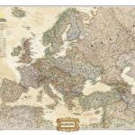
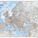
Political wall maps of Europe from the National Geographic Society in their executive style, offering current information in elegant antique presentation. Available either as 77 x 60cm or 117 x 92cm, both sizes on paper or encapsulated.The maps present Europe with relief shading to indicate mountainous regions. Additional graphics show topographic features such as main swamps or areas below the sea level. Heights are shown in feet. Names of various mountain chains, peaks, gulfs and bays, etc, provide additional topographic information.Countries are shown in different muted colours. All place names are in their English versions. Current edition shows Kosovo as an independent country, with a note referring to its still not fully formalized international status. Similar notes are provided for Cyprus and the Palestinian areas.The maps show the network of main road and rail connections. Also marked are selected ferry routes and North Sea oil fields. Latitude and longitude lines are drawn at 5ยฐ intervals.

Related Products:
 Europe NGS Executive Wall Map PAPER
 Europe NGS Executive Wall Map LARGE PAPER
 Europe NGS Executive Wall Map ENCAPSULATED
 Europe NGS Classic Wall Map PAPER
 Europe: Maps International Political Wall Maps
 Europe NGS Classic Wall Map LARGE PAPER
 Europe Maps International Political Wall Map X-LARGE PAPER
 Europe Maps International Political Wall Map PAPER LARGE
 World: National Geographic Society Executive Style Political Wall Maps
 Europe: Maps International Political Wall Map LARGE, HANGING STRIPS
Europe Maps International Political Wall Map LARGE ENCAPSULATED
Europe: Maps International Political Wall Map LARGE, HANGING STRIPS
Europe Maps International Political Wall Map LARGE ENCAPSULATED
 World Maps International Executive Political Wall Map
 Europe Maps International Political Wall Map X-LARGE ENCAPSULATED
 Europe NGS Classic Wall Map ENCAPSULATED
 Europe NGS Classic Wall Map LARGE ENCAPSULATED
 World: Global Mapping Antique Style Political Wall Maps
 South America: Maps International Political Wall Maps
 North America: Maps International Political Wall Maps
 World: National Geographic Society Classic Style Political Wall Maps
 Asia: Maps International Political Wall Maps
 Australasia: Maps International Political Wall Maps
 Africa: Maps International Political Wall Maps
 USA: NGS Executive Style Wall Maps
North America: Maps International Political Wall Map PAPER
Asia Maps International Political Wall Map PAPER
USA: NGS Executive Style Wall Maps
North America: Maps International Political Wall Map PAPER
Asia Maps International Political Wall Map PAPER
 World: Maps International Political Wall Maps
 Africa Maps International Political Wall Map PAPER
 South America Maps International Political Wall Map PAPER
Asia Maps International Political Wall Map HANGING STRIPS
Africa: Maps International Political Wall Map HANGING STRIPS
Asia Maps International Political Wall Map ENCAPSULATED
North America Maps International Political Wall Map HANGING STRIPS
South America: Maps International Political Wall Map HANGING STRIPS
Africa Maps International Political Wall Map ENCAPSULATED
South America Maps International Political Wall Map ENCAPSULATED
South America Maps International Political Wall Map PAPER
Asia Maps International Political Wall Map HANGING STRIPS
Africa: Maps International Political Wall Map HANGING STRIPS
Asia Maps International Political Wall Map ENCAPSULATED
North America Maps International Political Wall Map HANGING STRIPS
South America: Maps International Political Wall Map HANGING STRIPS
Africa Maps International Political Wall Map ENCAPSULATED
South America Maps International Political Wall Map ENCAPSULATED
 World: Global Mapping Political Wall Maps
 6
6
 Middle East: Maps International Political Wall Map