Disclosure : This site contains affiliate links to products. We may receive a commission for purchases made through these links.
Europe Central F&B
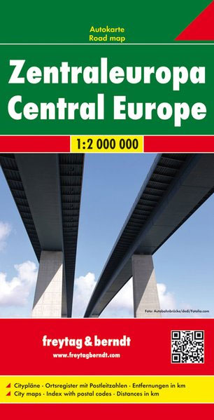
Central Europe at 1:2,000,000 from Freytag & Berndt, covering a large chunk of the Continent from Denmark to Sicily, with a separate index booklet also providing street plans of central areas in 25 capitals.Coverage extends from London and Barcelona to the eastern borders of Poland and Skopje, and from Gothenburg to Sicily, with Malta shown as an inset.Relief shading shows the topography and names of many mountain ranges, particularly within the Alpine areas, are indicated. The map shows road and rail network at the level appropriate to its scale, clearly indicating on main routes their road numbers, including where appropriate the E-numbers. Also marked are ferry connections, local airports, and within larger countries internal administrative boundaries. Latitude/longitude grid is drawn at intervals of 1ยบ. Map legend includes English. The index, arranged by country and for all except GB showing postcodes, is in a separate booklet attached to the map cover. The booklet also includes street plans of city centres in 25 capitals, including Monaco-Monte Carlo, San Marino and Valetta.

Related Products:
 Europe Eastern F&B
 Europe Western F&B
 Northern Europe – Scandinavia F&B
 Central Europe F&B Road Atlas
 Central Asia F&B
 Italy South F&B
 Central Macedonia Terrain Editions Regional Map 2
 Central Europe F&B Compact Road Atlas
 Sweden F&B
 Italy Central Michelin Regional 563
 Hungary F&B
 Sicily F&B Top 10 Tips 2-Map Set
 Europe Borch
 California F&B
 Central America Nelles
 Ukraine – Moldova F&B
 Central Silesia Hรถfer Road Map
 Belgium F&B
 Serbia North F&B
 Dalmatia – Croatia Coast Central and South
 Central Bohemia
 Denmark F&B
 Central Wielkopolska
 Europe F&B Compact Road Atlas
 Serbia South F&B
 Middle East F&B
 Portugal F&B
 Portugal Central Michelin Regional 592
 South Central USA 07 Hallwag Road Map
 Germany 700K F&B
 Central Crete Terrain Editions 449
 Turkey F&B
 Central Portugal Turinta
 Europe – Middle East – Central Asia F&B
 Central Asia Nelles
 Lima & Central Peru ITMB
 Italy North F&B
 Croatia – Montenegro Coast Cartographia 2-Map Set
 Sicily – Palermo – Catania K+F Regional Map 15
 Tokyo & Central Japan ITMB