Disclosure : This site contains affiliate links to products. We may receive a commission for purchases made through these links.
Etruscan Coast: Cecina to San Vincenzo 25K Ed. Multigraphic Map No. 539
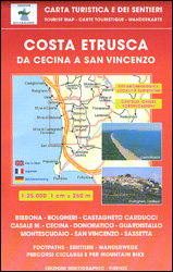
The Etruscan Coast of Tuscany between Cecina and San Vincenzo at 1:25,000 on a contoured map from Edizioni Multigraphic highlighting hiking paths, cycle routes archaeological sites, interesting locations, etc. Contours are at 25m intervals. The map has no geographical coordinates. Map legend includes English.Maps in this Edizioni Multigraphic series cover Tuscany, parts of Umbria, and some of the adjoining areas of central Italy. The cartography is rather old fashioned and sometimes not as clear as in other map series. Most maps have contours at 25-metre intervals, with some relief shading and colouring for forests. An overprint highlights hiking paths, including popular hiking routes such as the Grandi Sentieri della Provincia di Siena, etc. Some of the maps indicate latitude and longitude at the map corners, but with longitude sometimes based on Rome rather than Greenwich. Map legends vary, most maps include English. Many maps include street plans and additional notes on the region. For more details see individual descriptions.To see the list of all the titles in this series please click on the series link.

Related Products:
 Livorno Coast Edizioni Multigraphic 523
 Volterra and its Environs Edizioni Multigraphic 513
 Siena and Crete – Senesi West Edizioni Multigraphic 517
 San Gimignano – Colle Val d`Elsa – Poggibonsi Edizioni Multigraphic 511
 Florence and Surroundings Edizioni Multigraphic 510
 Garfagnana Edizioni Multigraphic 701
 Chianti – Val di Pesa – Val d`Elsa Edizioni Multigraphic 512
 Versilia – Riviera Apuana – Alpi Apuane Edizioni Multigraphic 711
 Parco della Maremma – Monti dell`e Uccellina Edizioni Multigraphic 504
 Appennino Pistoiese – Monti Pesciatini Edizioni Multigraphic 22
Chianti – Florence to Siena Edizioni Multigraphic 522
Appennino Pistoiese – Monti Pesciatini Edizioni Multigraphic 22
Chianti – Florence to Siena Edizioni Multigraphic 522
 Alta Maremma – Parco di Montioni 25K Ed. Multigraphic Map No. 507
S. Godenzo & the Surrounding Footpaths 25K Ed. Multigraphic Map No. 526
Alta Maremma – Parco di Montioni 25K Ed. Multigraphic Map No. 507
S. Godenzo & the Surrounding Footpaths 25K Ed. Multigraphic Map No. 526
 Alto Frignano – Appennino Modenese Edizioni Multigraphic 17
 Appennino Pistoiese e Modenese Edizioni Multigraphic 19
 San Miniato Commune 25K Ed. Multigraphic Map No. 521
 Chianti – Florence and Siena Edizioni Multigraphic 42/43
Appennino Parmense – Alta Lunigiana Edizioni Multigraphic 9
Appenninno Reggiano – Alta Garfagnana Edizioni Multigraphic 16
Chianti – Florence and Siena Edizioni Multigraphic 42/43
Appennino Parmense – Alta Lunigiana Edizioni Multigraphic 9
Appenninno Reggiano – Alta Garfagnana Edizioni Multigraphic 16
 Appennino Reggiano – Lunigiana – Garfagnana Edizioni Multigraphic 15
Valle di Roja – M. Toraggio – M. Grammondo Edizioni Multigraphic 113/114
Appennino Reggiano – Lunigiana – Garfagnana Edizioni Multigraphic 15
Valle di Roja – M. Toraggio – M. Grammondo Edizioni Multigraphic 113/114
 Elba & the Tuscan Archipelago 25K Ed. Multigraphic Map No. 502
 Monti Sibillini National Park Edizioni Multigraphic 60/61
Appennino Bolognese e Pistoiese Edizioni Multigraphic 21
Monti Sibillini National Park Edizioni Multigraphic 60/61
Appennino Bolognese e Pistoiese Edizioni Multigraphic 21
 Appennino Bolognese e Pratese Edizioni Multigraphic 23
 Appennino Cesenate – Val Tiberina Edizioni Multigraphic 34/36
 Gruppi Argentera e Marguareis Edizioni Multigraphic 109/115
 Crete Senesi 2 – Crete Senesi 25K Ed. Multigraphic Map No. 518
 Parco Regionale Migliarino – S. Rossore – Massaciuccoli Edizioni Multigraphic 503
 Appennino Parmense – Alta Lunigiana Edizioni Multigraphic 13
 The Hills of Siena & Bosco di Lecceto 25K Ed. Multigraphic Map No. 509
Italy: Ed. Multigraphic Walking Maps of Central Italy
Italy: Edizioni Multigraphic 25K Walking Maps of Central Italy
The Hills of Siena & Bosco di Lecceto 25K Ed. Multigraphic Map No. 509
Italy: Ed. Multigraphic Walking Maps of Central Italy
Italy: Edizioni Multigraphic 25K Walking Maps of Central Italy
 Alpi Apuane Edizioni Multigraphic 101/102
Bassa Lunigiana – Monte Marcello – Golfo della Spezia Edizioni Multigraphic 508
Imperia – San Remo – Ventimiglia Edizioni Multigraphic 111/112
Genoa – Varazze 25K Ed. Multigraphic Map No. 3/4
Casentino – Val Tiberina 25K Ed. Multigraphic Map No. 35
Massiccio del Pratomagno 25K Ed. Multigraphic Map No. 31/32
Alpi Apuane Edizioni Multigraphic 101/102
Bassa Lunigiana – Monte Marcello – Golfo della Spezia Edizioni Multigraphic 508
Imperia – San Remo – Ventimiglia Edizioni Multigraphic 111/112
Genoa – Varazze 25K Ed. Multigraphic Map No. 3/4
Casentino – Val Tiberina 25K Ed. Multigraphic Map No. 35
Massiccio del Pratomagno 25K Ed. Multigraphic Map No. 31/32
 Rome and Environs 25K Ed. Multigraphic Map No. 501