Disclosure : This site contains affiliate links to products. We may receive a commission for purchases made through these links.
Eleuthera Island – Bahamas Adventure Map-Guide
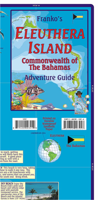
Eleuthera Island in the Bahamas on an adventure map/guide from Franco Maps ‘“ publishers who specialize in maps with extensive information for diving and snorkeling. On the reverse are enlargements of parts of Eleuthera, plus a map of the whole of the Bahamas.On one side is a map of Eleuthera Island annotated with both places of interest on land and locations of numerous diving and snorkelling sites in its coastal waters. The sites are annotated with brief descriptions, indicating, where appropriate, the depth in metres and feet. Three monthly graphs show air temperature and precipitation, water temperature and colour, and water visibility. The map is decorated with lovely colour drawings of numerous species of fish found in the surrounding seas.On the reverse, enlargements accompanied by descriptions show in greater detail Harbour Island with Dunmore Town, Governor’s Harbour (with a locator of 80 facilities) and Rock Sound. Also provided is a map of the whole Bahamas archipelago with brief notes about most of the islands.

Related Products:
 Great Abaco – Bahamas Franko Adventure & Dive Map-Guide
 Palau Franko`s Adventure & Dive Map-Guide
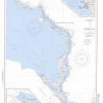
 NGA Chart 26280 – Eleuthera Island to Crooked Island Passage
 Florida Keys Adventure & Dive Map-Guide
Cozumel “Island of Peace” Franko`s Dive & Guide Map
Florida Keys Adventure & Dive Map-Guide
Cozumel “Island of Peace” Franko`s Dive & Guide Map
 Bahamas ITMB
 A Cruising Guide to: The Northern Bahamas
 NGA Chart 26306 – Eleuthera – West Part (Bahamas)
Curaรงao Dive Map/Guide
NGA Chart 26306 – Eleuthera – West Part (Bahamas)
Curaรงao Dive Map/Guide
 Reg 9.2 Bahamas Central
 US Virgin Islands Adventure and Dive Map/Guide
 NGA Chart 26300 – Little Bahama Bank to Eleuthera Island
 Explorer Chartbook Far Bahamas 7th Edition
 Bahamas Overall Chart
 Cayman Islands Guide & Dive Map
 A Cruising Guide to: The Southern Bahamas
 Caribbean – Central America – Virgin Islands – Bahamas
 The Great Book Of Anchorages The Bahamas
 Moon Bahamas
 Zanzibar Island
 Cruising Guide Abaco Bahamas 2018
 Bahamas Pilots Guide 2018
 Waterway Guide Bahamas 2021
 Reg 9.1 Bahamas Northwest
Belize Dive Map
Fodor`s Bahamas
Reg 9.1 Bahamas Northwest
Belize Dive Map
Fodor`s Bahamas
 The Captain`s Guide to Hurricane Holes: The Bahamas and Caribbean
 Reg 9.3 Bahamas Southeast
 Peru de Dios Map-Guide
 Dominican Republic NGS Adventure Map 3102
California: Sacramento’“San Joaquin River Delta Adventure Map/Guide
Dominican Republic NGS Adventure Map 3102
California: Sacramento’“San Joaquin River Delta Adventure Map/Guide
 Explorer Chartbook Near Bahamas 9th Edition
 British Virgin Islands Franko`s Map-Guide
 NGA Chart 26307 – Eleuthera – East Part
 Easter Island / Rapa Nui
 Hawaii – The Big Island Nelles
 O`ahu Island and Honolulu
 Oahu, Honolulu & Big Island ITMB
 The Kimberley (WA) Moon Adventure Publications Travel & Adventure Guide