Disclosure : This site contains affiliate links to products. We may receive a commission for purchases made through these links.
Elbasan – Berat
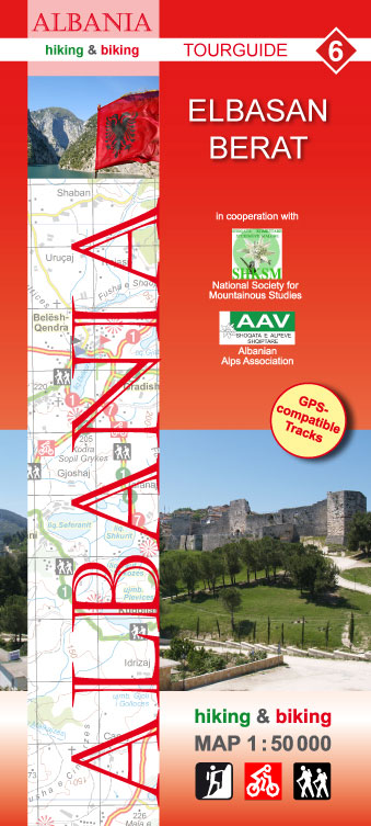
Elbasan – Berat area of central Albania at 1:50,000 in a series of GPS compatible contoured maps from Huber Verlag showing hiking and cycling routes, climbing sites, tourist accommodation, etc. Descriptions cover 13 cycling routes and five hiking trails.Maps in this series, prepared in cooperation with the Albanian Alps Associations and the National Society for Mountainous Studies, have contours at 50m intervals, with spot heights, graphic relief for exposed rocky areas and colouring showing woodlands. Recommended hiking and cycling routes are prominently marked and cross-referenced to descriptions on the reverse side. Interesting towns and villages are highlighted and symbols indicate hotels and other tourist accommodation, sites for climbing and/or kayaking, museums, archaeological remains, medical facilities, etc. The maps have a 1-km UTM grid. On the reverse are detailed descriptions of the recommended hiking and cycling trails accompanied in some titles by route profiles. Map legend and all the text include English.To see other titles in this series please click on the series link.

Related Products:
 Korรงa and Environs
 Puka and Environs
 Saranda and Environs
 Vlora and Environs
 Tirana – Durrรซs – Kruja
 Shkodra and Environs
 Tropoja – B. Curri – Valbona
 Vermoshi – Tamare – Razma – Thethi
 Albania: Huber Verlag 50K Hiking and Cycling Maps
 Romania: Bel Alpin Hiking Maps
 Triglav Pocket Map
 Paklenica National Park Croatian Mountain Rescue Service 25K Map
 Siniscola
 Ibiza – Formentera Editorial Alpina
Posada
Ibiza – Formentera Editorial Alpina
Posada
 Bled Pocket Map
 Bihor Mountains Dimap Hiking Map
 Tarcau Mountains and Ghimes Dimap Hiking Map
 Cabo de Gata-Nรญjar Natural Park Editorial Alpina
 Picos de Europa National Park 3-Map and Guide Set CNIG ENGLISH
 Picos de Europa National Park 3-Map and Guide Set CNIG SPANISH
 Montes de Malaga Map-Guide ENGLISH
 Montes de Malaga Map-Guide SPANISH
 Muntanya d’Alinyร Editorial Alpina
 Postavarul and Piatra Mare Mountains
 Sierra de Guadarrama National Park 4-Map and Guide Set CNIG
 Kamnik and Savinja Alps Kartografija WATERPROOF Hiking Map
Isola di San Pietro
Kamnik and Savinja Alps Kartografija WATERPROOF Hiking Map
Isola di San Pietro
 Danube Bend Cartographia Tourist Map 31
 Greece: Terrain Editions Maps for Hiking and Recreational Pursuits
 Mรกtra Cartographia Tourist Map 14
 Zselic Cartographia Tourist Map 17
 Gerecse Cartographia Tourist Map 10
 Fagaras Mountains Dimap Hiking Map
 Gulf of Orosei
Gulf of Oristano
Gulf of Orosei
Gulf of Oristano
 Borzsony Cartographia Tourist Map 5
 Bรผkk Cartographia Tourist Map 29
 Vรฉrtes Cartographia Tourist Map 20