Disclosure : This site contains affiliate links to products. We may receive a commission for purchases made through these links.
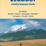
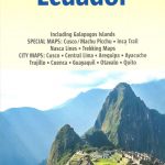
Ecuador ITMB

Ecuador at 1:660,000 an indexed, double-sided map from ITMB printed on light, waterproof and tear-resistant synthetic paper. The map has altitude coluring to show the topography, plus street plans of Quito and Guayaquil, and an enlargement of the Quito region with Otavalo and several of the country’s volcanoes including Cotopaxi and Cayambe.The map is double-sided, dividing the country north/south with a good overlap between the sides. Relief is shown by altitude tinting and spot heights for peaks and volcanoes. Glaciers, swamp areas, national parks and reserves are marked. Road information indicates paved and unpaved secondary roads and includes season roads and selected tracks. Intermediate driving distances shown on main routes and locations of petrol stations are marked. Railway lines are included; local airports and in more remote areas landing strips are marked. The map also shows internal administrative boundaries with names of the provinces.Symbols highlight various places of interest including active/inactive volcanoes, thermal springs, national parks and nature reserves, bird watching sites, beaches, diving sites, etc. Latitude and longitude lines are drawn at 1ยฐ intervals. Each side has a separate index. Two insets provide clear street plans of Quito’s most visited areas: the Old Town and the Mariscal district. Both show public transport routes and various places of interest and facilities. A small, more basic street plan shows Guayaquil. Also provided is an enlargement of the Quito region extending north to Otavalo and Ibarra, and south to Latacunga. The region’s national parks and its active volcanoes, including Cotopaxi and Cayambe are highlighted.

Related Products:
 Quito & Central Ecuador ITMB
 Galapagos Islands – Quito & Guayaquil ITMB
 Ecuador Borch
 Cotopaxi
 Colombia – Ecuador Nelles
 Guatemala ITMB
 Peru – Ecuador Nelles
 Paraguay – Bolivia South ITMB
 USA South: Atlantic States ITMB
 South America ITMB
 Africa ITMB
 Africa Northwest ITMB
 India ITMB
 Japan North & Hokkaido ITMB
 Uganda ITMB
 Colombia ITMB
 Accra & Ghana South ITMB
 San Diego & USA South West Border ITMB
 Belize & Eastern Guatemala ITMB
 Kamchatka & Eastern Siberia ITMB
 Armenia & Azerbaijan ITMB
 Santiago & Chile North ITMB
 Nepal ITMB
 Cuba West ITMB
 South America – The Andes Nelles
 Japan South ITMB Railway & Road Map
 Ecuador – Galapagos Islands Reise Know-How
 Seattle & Northwest USA ITMB
 San Francisco & Northern California ITMB
 Bahamas ITMB
 Argentina South & Tierra del Fuego ITMB
 California ITMB
 Namibia ITMB
New Zealand ITMB
Namibia ITMB
New Zealand ITMB
 Central America ITMB
 South America ITMB Travel Atlas
 Georgia & Armenia ITMB
 Rome & Southern Italy ITMB
 Kilimanjaro & Tanzania North ITMB