Disclosure : This site contains affiliate links to products. We may receive a commission for purchases made through these links.
Eastern Rhodope Mountains
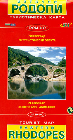
Eastern Rhodope Mountains on a detailed road map at 1:120,000 from Domino with a street plan of Zlatograd, brief descriptions of 87 places of interest, plus on the reverse plans of the archaeological remains at Perperikon and Tatul.On one side is a detailed road map of the eastern part of the Rhodope Mountain along the Greek border. Coverage extends from Zlatagrad in the south-west to Svilengrad in the north-eastern corner. Topography is shown by contours at 50m intervals with faint relief shading and spot heights, plus colouring for forested areas. Boundaries of protected areas are indicated. All place names apart from selected towns plus locations cross-referenced to the descriptions are given in Cyrillic alphabet only.Road network includes dirt roads or tracks and selected local paths. Railway lines are shown with stations and stops. Various places of interest are highlighted by small drawings and/or cross-referenced to English language descriptions next to the map. The map has no geographical coordinates or an index. Map legend includes English.Also provided is a street plan of Zlatograd with a brief description of its sites and a Bulgarian only legend.The whole of the reverse side is taken up by 3-D drawings of the archaeological remains at Perperikon and Tatul, with bilingual notes.

Related Products:
 Western Rhodope Mountains Domino Map
 Strandzha Mountains: Burgas to the Turkish Border Domino Map
 Eastern Svealand Norstedts Regional Map 3
 Eastern Wielkopolska
 Eastern Pomerania
North Eastern Bohemia – Lower Silesia Hรถfer Road Map
Eastern Pomerania
North Eastern Bohemia – Lower Silesia Hรถfer Road Map
 Thrace and Eastern Macedonia Terrain Editions Regional Map 1
 Southern Pomerania – North Eastern Wielkopolska
 Mount Olympos Region – Eastern Lycia
 Eastern Rhodopes / Rodopi Geopsis 131
 Australia Eastern Reise Know-How
 Cindrel Mountains
 Transylvania South-Eastern Gizi Map
 Lasithi – Eastern Crete Anavasi 92
 Honduras Protected Areas Map
 Zambia & Eastern Africa ITMB Road Map
 Turkish Riviera – Antalya – Side – Alanya Top 10 Tips
 Birdsville and Strzelecki Tracks, SA/QLD/NSW
 Monti Iblei – South-Eastern Sicily Global Map Tourist Map
 Eastern Texas Benchmark Recreation Map
 Belize & Eastern Guatemala ITMB
 Poland`s Tourist Attractions Map
 Europe Eastern Jana Seta Road Map
 Bosnia-Herzegovina F&B Top 10 Tips
 Drakensberg and the Eastern Free State
 Alice Springs to Uluru (Ayers Rock)
 Russia – C. I. S. F&B
 Eastern Crete Terrain Editions 450
 Syria – Lebanon
 Bucegi Mountains
 Tatra Mountains PL/SK
 USA North-Eastern: Maine to WashingtoN DC (CT, DE, ME, MD, MA, NH, NJ, NY, OH, PA, RI, VT, WV) Reise-Know-How Map
 Nay Pyi Taw & Yangon (Rangoon) Odyssey Map
 Bolivia de Dios Map-Guide
 Mani Anavasi 8.4
 Retezat Mountains
 Frosch Cycle Tour: North-Eastern Saxony (274km) Bikeline Map/Guide
Pilgrim Routes in the Florentine Countryside: Eastern Part
Frosch Cycle Tour: North-Eastern Saxony (274km) Bikeline Map/Guide
Pilgrim Routes in the Florentine Countryside: Eastern Part
 North-Eastern Thailand
 Central and Eastern Thailand