Disclosure : This site contains affiliate links to products. We may receive a commission for purchases made through these links.
East Tibet Gecko Map
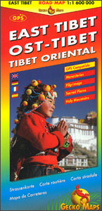
The eastern part of Tibet at 1:1,600,000 on a double-sided map from Swiss publishers Gecko Maps, with excellent presentation of the topography and plenty of names of local villages, places of interest and facilities including tourist accommodation, villages interesting markets or food shops, etc. The map divides the region north/south, extending on the southern side from west of Lhasa and most of Bhutan to beyond Chengdu and Kunming; the reverse side extends coverage northwards well beyond Lanzhou to the latitude of 40ยบ. All place names are in the Latin alphabet, showing where useful both the Tibetan and the Chinese name; names of larger locations and selected tourist destinations are also given in the Tibetan alphabet.Topography is presented by relief shading and plenty of spot heights, plus altitude colouring which also indicates the influence of the monsoon (as in the publishers’ companion map ‘Himalaya ‘“ Tibet”). The region`s dense network of rivers and lakes is shown with swamps, salt swamps and lakes, and seasonal rivers. Road network includes secondary roads and tracks, and shows driving distances on main routes and locations of border crossings. Railway lines include the Golmud – Lhasa route and the map also indicates local airports/airfields and helicopter landing sites. Symbols highlight various places of interest, including religious sites, and selected locations with tourist accommodation, shops or medical facilities. The map also shows provincial and county administrative boundaries and names. Latitude and longitude lines are drawn at 1ยบ intervals. Map legend includes English.

Related Products:
 Tibet ITMB
 Tibet Reise Know-How
 Tibet Gizi Map
 Tibet Gizi Road Map
 Tibet Road Edition Wall Map
 Tibet Geographical Edition Wall Map
 Tibet – Mount Everest – Nam Tso – Lhasa – Shigatse terraQuest Tourist Map
 Lhasa: On this Spot Map and Guide
 Trekking in Tibet – A Traveller`s Guide
 Magic and Mystery in Tibet
 Mount Kailash Trek – Tibet`s Sacred Mountain & Western Tibet
 Tibet: A History Between Dream and Nation State
 Tibet on Fire: Self-Immolations Against Chinese Rule
 Eat the Buddha: The Story of Modern Tibet Through the People of One Town
 China South ITMB
 From Lhasa to Kailas
 Middle East Gizi Map
 Middle East Wall Map
 Discovering Tibet: The Tucci Expeditions and Tibetan Paintings
 Tibet Bradt Guide
 The Art of Tibet
 The Friendship Highway: Two Journeys in Tibet
 Pamirs Gecko Tourist Map
 Tibet: An Unfinished Story
 Kailash
 Tibet: A Culture on the Edge
 Nepal Gecko Map
 Tibetan on Tibet
 Plovdiv
 China West ITMB
 Lesbos Geopsis 211
 Tibet Unconquered – The Epic Struggle for Independence
 Himalaya ITMB
 Pleven
 Smolyan – Chepelare – Pamorovo and the Surrounding Area
 Tibet – Turning the Wheel of Life
 Cambodia Gecko Map
Oman & Yemen ITMB
Cambodia Gecko Map
Oman & Yemen ITMB
 Dhofar Road Map – Salalah and Southern Oman
 A Year In Tibet