Disclosure : This site contains affiliate links to products. We may receive a commission for purchases made through these links.
Dudley West 1901
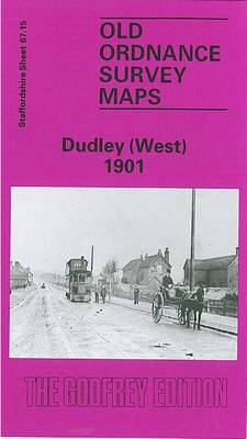
Dudley West in 1901 in a fascinating series of reproductions of old Ordnance Survey plans in the Alan Godfrey Editions, ideal for anyone interested in the history of their neighbourhood or family. Two versions have been published for this area. The maps cover the western part of Dudley town, including the Old Dock area, and extend westward to the Old Park area, and southward to Scotts Green and Blowers Green. Other districts mentioned include Thornleigh Collieries, Springs Mire, New Dock, Sunnyside. The area is split between Staffordshire and Worcestershire, and doubles as Worcestershire sheet 1.15. Features include tramways, short stretch of GWR OWW line, several mineral railways, Yorkspark Colliery (disused), Thornleigh Works, old mine shafts, public baths, St Luke`s church, schools, Russell`s Hall, Himley Colliery, Graveyard Farm, Parkhead Colliery (disused), St Augustine`s church, expanses of old industrial sites and coalfield, etc. The 1881 version is in colour, taken from the beautiful hand-coloured OS 1st Edition map.About the Alan Godfrey Editions of the 25″ OS SeriesSelected towns in Great Britain and Ireland are covered by maps showing the extent of urban development in the last decades of the 19th and early 20th century. The plans have been taken from the Ordnance Survey mapping and reprinted at about 15 inches to one mile (1:4,340). On the reverse most maps have historical notes and many also include extracts from contemporary directories. Most maps cover about one mile (1.6kms) north/south, one and a half miles (2.4kms) across; adjoining sheets can be combined to provide wider coverage.FOR MORE INFORMATION AND A COMPLETE LIST OF ALL AVAILABLE TITLES PLEASE CLICK ON THE SERIES LINK.

Related Products:
 Dudley (West) 1881 – 67.15a Coloured Edition
 Dudley Castle 1901
 Dudley 1882 – 67.16a Coloured Edition
 Cradley Heath and Old Hill 1901
 Sedgley South-East with Swan Village and West Coseley 1901
Cradley South 1901
Sedgley South-East with Swan Village and West Coseley 1901
Cradley South 1901
 Willenhall (NW) & Wednesfield 1901 – 62.08a
 Shut End and Tansey Green 1903
Halesowen (West) 1901 – 4.16
Darlaston & King`s Hill 1901
Wollaston 1901 – 4.09
Harborne South 1901
Stourport 1901
Shut End and Tansey Green 1903
Halesowen (West) 1901 – 4.16
Darlaston & King`s Hill 1901
Wollaston 1901 – 4.09
Harborne South 1901
Stourport 1901
 Bescot 1901
Wolverhampton North West 1901
Dudley, Bridgnorth and District 1898
Bangor West 1901
West Bromwich 1902 – 68.10b
Horsehay and Dawley 1901
Hindley Green 1906
Kilnhurst 1901
Wakefield West 1905
Dundee East 1901
Bescot 1901
Wolverhampton North West 1901
Dudley, Bridgnorth and District 1898
Bangor West 1901
West Bromwich 1902 – 68.10b
Horsehay and Dawley 1901
Hindley Green 1906
Kilnhurst 1901
Wakefield West 1905
Dundee East 1901
 Wolverhampton (SE) 1901 – 62.11b
Seaham Harbour 1895
Wolverhampton (SE) 1901 – 62.11b
Seaham Harbour 1895
 West Bromwich (North) 1885 – 68.06a Coloured Edition
 Greets Green 1902
Sherborne 1901
Mexborough 1901
Trimdon Grange 1914
Conisbrough 1901
Bristol (St George) 1902 – 72.14
Wath upon Dearne 1901
Shire Oak and Catshill 1901
Greets Green 1902
Sherborne 1901
Mexborough 1901
Trimdon Grange 1914
Conisbrough 1901
Bristol (St George) 1902 – 72.14
Wath upon Dearne 1901
Shire Oak and Catshill 1901
 Oldbury & Spon Lane 1904 – 68.14a
Stourbridge (North) & Amblecote 1901 – 4.10a
Dundee West 1901
Oldbury & Spon Lane 1904 – 68.14a
Stourbridge (North) & Amblecote 1901 – 4.10a
Dundee West 1901
 Harborne 1901
 Kiveton Park and Wales 1901
 Wickersley 1901