Disclosure : This site contains affiliate links to products. We may receive a commission for purchases made through these links.
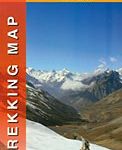
Drakensberg – Ukhahlamba Park terraQuest Trekking Map
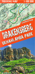
uKhahlamba – Drakensberg Park at 1:100,000 on a durable, waterproof and tear-resistant, contoured and GPS compatible trekking map from terraQuest. The map is double-sided and covers the park in two overlapping sections. Coverage extends north-west to include the Royal Natal National Park.Topography is vividly presented by contours at 25m intervals, enhanced by relief shading plus colouring indicating forests, shrubland, wetlands and agricultural areas. The map shows the region’s road network, including rural roads and footpaths, and highlights trekking trails indicating difficult sections. Symbols show locations of hotels, mountain refuges and campsites, bivouac and picnic places, restaurants, car parks and petrol stations, medical facilities, viewpoints, etc. The map has latitude and longitude lines at intervals of 1’. Multilingual map legend includes English.Please note: contours and relief shading continues within Lesotho, including the marking for the Grand Traverse trail between the La Namah Pass and the Thomathu Pass. Other information is more limited than on the South African side of the mountains.The map is laminated in a format similar to the old cloth-dissected maps so that sections of it can be easily folded back without damage.

Related Products:
 Tian Shan – Khan Tengri – Pobeda Peak – Lenin Peak terraQuest Trekking Map
 Aconcagua terraQuest Trekking Map
 Georgian Caucasus – Mt Ushba – Shkhara – Kazbek terraQuest Trekking Map
 Fagaras – Bucegi – Piatra Craiului terraQuest Trekking Map
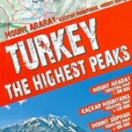 Turkey`s Highest Peaks – Mount Ararat – Kackar Mountains – Mount Suphan terraQuest Trekking Map
 Indian Himalaya terraQuest Trekking Map
 Lake Como terraQuest Trekking Map
 Lake Garda terraQuest Trekking Map
 Central Pyrenees terraQuest Trekking Map
 Karakoram – K2 – Gasherbrum – Broad Peak terraQuest Trekking Map
 Africa`s Highest Peaks – Kilimanjaro – Mount Kenya – Rwenzori terraQuest Trekking Map
 Madeira terraQuest Trekking Map
 Ushuaia Trekking Map
 Paklenica National Park
 Rila – Pirin terraQuest Trekking Map
 Peru: Alpenvereinskarte Trekking Maps
 Tibet – Mount Everest – Nam Tso – Lhasa – Shigatse terraQuest Tourist Map
 Khumbu – Sagarmatha National Park
 Montserrat Nature Park Editorial Alpina
 Skadar Lake National Park
 Shivapuri Nagarjun National Park
 Torres del Paine Trekking Map
 Patagonia – Fitz Roy – Cerro Torre – Perito Moreno Glac – Torres del Paine terraQuest Trekking Map
 Maritime Alps Natural Park – Entracque – Valdieri – Mercantour – Gelas IGC 113
 Paklenica National Park Croatian Mountain Rescue Service 25K Map
 Aconcagua Climbing and Trekking Map
 Tsum Valley Trekking Map
 High Atlas – Jbel – Toubkal terraQuest Trekking Map
 Monti Sibillini National Park Edizioni Multigraphic 60/61
 Cap de Creus Park Natural Editorial Alpina
 Lemmenjoki National Park
 Damavand Climbing and Trekking Map
 Triglav National Park
 Antuco – Laguna del Laja National Park
 Timanfaya National Park – Lanzarote CNIG Map-Guide ENGLISH
 Garajonay National Park – Gomera CNIG Map-Guide ENGLISH
 Walking in the Drakensberg: 75 Walks in the Maloti-Drakensberg Park
 Auyuittuq National Park, Nunavut
 Picos de Europa National Park 2-Map Set Editorial Alpina
 Bavarian Forest National Park – Nature Park East UK50-29