Disclosure : This site contains affiliate links to products. We may receive a commission for purchases made through these links.
Dominican Republic NGS Adventure Map 3102
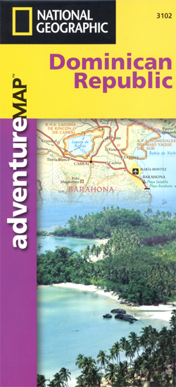
Dominican Republic at 1:450,000 on a waterproof and tear-resistant map from the National Geographic Society, with on the reverse street plans and enlargements for most visited areas, all illustrated with numerous colour photos and descriptions.On one side is a map of the whole country at 1:450,000. Topography is very effectively presented by contours at 100m intervals with additional altitude shading, spot heights and names of mountain ranges, plus graphics and/or colouring for forested areas, swamps, mangrove and coral reefs in the coastal waters. Road network includes selected tracks and paths, with distances shown on main routes. Crossing points to Haiti are indicated, and domestic airports or airstrips are marked. Also shown are internal administrative boundaries with names of the provinces.Symbols highlight various places of interest, including surfing, diving and deep sea fishing sights, shipwrecks, golf courses, caves, etc. The map also prominently shows the country’s numerous protected areas, with a separate index listing national parks, forest reserves, natural monuments, national recreation areas, scientific reserves, wildlife refuges and marine mammal sanctuaries. The map has a UTM grid, plus latitude and longitude margin ticks at intervals of 20’. Apart from the protected areas, only a short index of selected towns is provided.On the reverse is an overview plan of Santo Domingo, naming main streets and districts and indicating locations of main sights. A more detailed enlargement shows the Colonial Old City. Also provided are enlargements showing in greater detail the Samana Peninsula, Lake Enriquillo and environs, Del Este National Park and the Cordillera Central around Pico Duarte, the highest point in the Caribbean.Across both sides of the map are numerous colour photos and descriptions of sights, fauna and flora.

Related Products:
 Nepal Adventure Map
 Dominican Republic & Haiti ITMB
 Belize NGS Adventure Map 3106
 Guatemala NGS Adventure Map 3110
 Dominican Republic – Haiti Reise Know-How
 Czech Republic F&B
 Poland`s Tourist Attractions Map
 China Adventure Map
 Namibia Map Studio Adventure Map
 The People`s Republic of China Administrative Map
 Czech Republic Road Atlas
 Costa Rica NGS Adventure Map 3100
 China East Adventure Map
 Central African Republic IGN 85011
 Ecuador – Galapagos NGS Adventure Map 3403
 France Adventure Map
 Thailand Adventure Map
 Peru NGS Adventure Map 3404
 Zimbabwe Map Studio Adventure Map
 Myeik Archipelago & Myanmar (Burma) Odyssey Map
 Chile NGS Adventure Map 3402
 Ireland Adventure Map
 Egypt NGS Adventure Map 3202
 South Africa Adventure Map
 The Dominican Republic Reader: History, Culture, Politics
 Puerto Rico NGS Adventure Map 3107
 Nicaragua – Honduras – El Salvador NGS Adventure Map 3109
 Dominican Republic Traveler Guide
 Mexico NGS Adventure Map 3108
 Congo, Democratic Republic
 Australia Hema Road & Terrain Map
 Southern Sweden and Norway Adventure Map
 Finland and Northern Scandinavia NGS Adventure Map 3300
 Jordan
 Czech Republic F&B Superatlas
 Germany Adventure Map
 Cambodia – the Khmer Legacy Odyssey Illustrated Map
 Czech Republic Marco Polo Road Atlas
 Southern France Adventure Map
 Outback New South Wales – from Broken Hill to Tamworth Hema Explorer Map