Disclosure : This site contains affiliate links to products. We may receive a commission for purchases made through these links.
Dominica & Saint Lucia ITMB

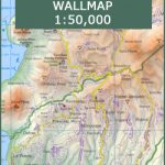
Dominica and Saint Lucia on a double-sided map from ITMB showing each island on one side accompanied by street plans of Roseau and Castries respectively. The islands’ topography is shown by contours and altitude colouring.On one side is Dominica at 1:50,000. Contour lines are at 25m intervals. The Waiukubuli National Hiking Trail is prominently marked. On the reverse, St Lucia is shown at 1:40,000 with contours at 50m. On both islands the map indicates protected areas and shows the road network, including dirt roads. Symbols highlight various places of interest, including selected tourist accommodation, beaches and snorkeling/diving sites, etc. Each side is indexed and has latitude and longitude lines at 5’ on Dominica and at 2’ on St Lucia. Street plans cover the town centres of Roseau and Castries showing locations of selected hotels and other facilities.

Related Products:
 Antigua & Dominica ITMB
 St Lucia & Dominica Footprint Handbook
 Saint Lucia
 Caribbean Islands East & South ITMB Travel Atlas
 Guadeloupe & Dominica ITMB
 St Lucia Wall Map
 St Lucia Gizi Map
 Dominica
Barbados & Saint Lucia ITMB
Dominica
Barbados & Saint Lucia ITMB
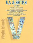
 Virgin Islands (US and British) ITMB
 Saint Lucia & Martinique ITMB
 Cayman Islands & Jamaica ITMB
 Bahamas ITMB
 Romania & Moldova ITMB
 Hawaii & Honolulu ITMB
 Belize & Eastern Guatemala ITMB
 Bali & Lombok ITMB
 Martinique & Guadeloupe ITMB
 Guyana, Suriname & French Guiana ITMB
 Belarus ITMB
 Fiji & Tonga ITMB
 Cuba ITMB
 Morocco ITMB
 Georgia & Armenia ITMB
 A29 Dominica
Malta & Gozo ITMB
A29 Dominica
Malta & Gozo ITMB
 Polynesian Islands ITMB Travel Atlas
 Japan North & Hokkaido ITMB
 Sumatra ITMB
 Namibia ITMB
 California ITMB
 Tahiti & Cook Islands ITMB
 Sarawak – Sabah – Brunei ITMB
 Caribbean Islands Western Half ITMB Travel Atlas
 Togo & Benin ITMB
 Argentina North & Uruguay ITMB
 Virgin Islands Borch
 Ghana ITMB