Disclosure : This site contains affiliate links to products. We may receive a commission for purchases made through these links.
Dinara – Troglav Group East
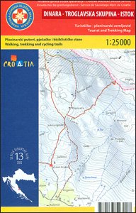
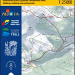
The south-eastern part of the Dinara – Troglav mountain range on the border of southern Croatia and Bosnia-Herzegovina on a contoured and GPS compatible map at 1:25,000 from the Croatian Mountain Rescue Service. Coverage extends southwards from the peak of Troglav to Maljkovo near the Perucko Lake.Contours at 10m intervals enhanced by relief shading provide excellent presentation of the terrain, with markings for various topographic features. Waymarked hiking trails are highlighted, indicating sections where hikers must remain on the path due to the possibility of landmines still remaining in the surrounding area from the war over the breakup of Yugoslavia. Trails on the Bosnian side of the border are mainly on the southern slopes of Troglav. Road network in Croatia shows recommended cycling routes and symbols indicate various facilities and places of interest, including mountain huts and shelters, paragliding sites, etc. The map has a 1km UTM grid, plus latitude and longitude lines at 1’ intervals. On the reverse are recommendations for five hiking routes, details of local shelters, plus general information about the area illustrated with colour photos. Map legend and all the text include English.This map is printed on demand, and if it`s out of stock it could take 3 – 4 months waiting time.To see the list of titles in this series please click on the series link.

Related Products:
 Dinara – Troglav Group West
 Dinara
 Kameลกnica Mountain Croatian Mountain Rescue Service 25K Map
 Omiลกka Dinara
 Mallorca East Reise Know-How
 Kamnik and Savinja Alps Kartografija WATERPROOF Hiking Map
 Merano and Environs – Texel Group – Sarntal – Bolzano K+F Outdoor Map 2
 Pays Basque East Rando Editions 2
 Kitzbuhel Alps East Alpenverein Map 34/2
 Zillertal Alps East Alpenverein KOMBI Map 35/3
 Allgau-Lechtal Alps East Alpenverein Map 2/2
 Finland East Karttakeskus Outdoor Road Map
 Kitzbuhel Alps East Alpenverein SKI Map 34/2
 El Ports: Southern Stars Long-distance Hiking Route
 Wetterstein – Mieminger Gebirge East Alpenverein Map 4/3
 Totes Gebirge East Alpenverein KOMBI Map 15/3
 Pirin (BG) – Orvilos – Vrontou (GR) Geopsis 134
 Mallorca Central Plain – East and South Coasts Editorial Alpina
 Appennino Tosco-Romagnolo East
 Brenta Group World Heritage Site Kompass 73
 Mallorca South Reise Know-How
 Africa East & Central ITMB
 Ammergebirge East – Pรผrschling – Hรถrnle
 Coast to Coast East Mountain Bikers & Cyclists: Kirkby Stephen to Robin Hood`s Bay
 Western Tatras – Polish and Slovak
 South-East Styrian Hills – Vulkanland – Bad Gleichenberg – Bad Radkersburg F&B WK412
 Croatia: Mountain Rescue Service Recreational Maps
 Pica d`Estats – Mont-roig Editorial Alpina
 Chiemgau Alps East – Sonntagshorn Alpenverein KOMBI BY19
 Lake Constance East
 Sierra Nevada – the Alpujarra – Marquesado del Zenete Editorial Penibetica Map and Guide
Mangfallgebirge East – Wendelstein – Grosser Traithen Alpenverein KOMBI BY16
Sierra Nevada – the Alpujarra – Marquesado del Zenete Editorial Penibetica Map and Guide
Mangfallgebirge East – Wendelstein – Grosser Traithen Alpenverein KOMBI BY16
 Pica d`Estats – Mont-roig – Vall Ferrera – Valls de Cardos Editorial Alpina
 Balkans – South-East Europe F&B
 ร…re Lantmateriet Z51
 Whistler and Sea-to-Sky Highway ITMB
 Glockner Group – Hohe Tauern National Park Kompass 39
 Paklenica National Park Croatian Mountain Rescue Service 25K Map
 Oviksfjรคllen Lantmateriet Z55
 Sylarna – Helags Lantmateriet Z54