Disclosure : This site contains affiliate links to products. We may receive a commission for purchases made through these links.
Dartmouth – Dittisham & Coast to Brixham Walking Map 26
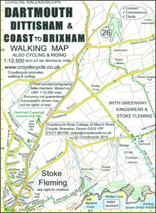
Dartmouth – Dittisham & Coast to Brixham Walking Map at 1:12,500 from Croydecycle covering River Dart’s estuary; handy size, double-sided, contoured, printed on light waterproof and tear-resistant synthetic paper and showing National Cycle routes and numerous local facilities, including campsites, pubs, etc.Topography is indicated by contours at 10m intervals, with colouring for different types of vegetation including woodlands with public access. The map also shows the high tide level and classifies beaches as sand, shingle, boulders or rock. Where appropriate, the paths or the terrain are annotated with comments providing useful advice for bikers and hikers. Roads are presented according to the density of traffic and have gradient markings. An overprint indicates cycle paths and private roads with access on bike or foot, as well as bridleways, footpaths and permissive paths. On roads which are part of the National Cycle Network route numbers are marked. Symbols indicate numerous facilities: campsites and caravan sites, pubs and cafes, car parks and picnic sites, local shops, cycle hire, tourist information, etc. National Grid coordinates are marked in the margins.To see other titles in this series please click on the series link.

Related Products:
 Totnes & Dartmouth Cycle Map 62
 Totnes Walking Map 28
 Budleigh Salterton & Otterton Walking Map 40
 Braunton & Ilfracombe Cycle Map 60 – with Tarka Trail & Barnstaple
 Exmouth & Sidmouth Cycle Map 61
 Dartmouth & Slapton Walking Map 25
 South Devon Cycling Map 83
 North Devon Cycling Map 82
 Cornwall East – Bodmin/St Austell to West Devon Cycling Map 81
 East Devon – Exeter Cycling Map 85
 Exmoor & Taunton Cycling Map 84
 Cornwall West – Lands End to Bodmin/St Austell Cycling Map 80
 Devon Coast to Coast – Route 27 Cycle Map 66
 Dittisham & Cornworthy Walking Map 27 – Totnes to Dartmouth incl Greenway
 Sidmouth Walking Map 42
 Porlock Walking Map 02
 Mortehoe & Woolacombe Walking Map 07
 Ilfracombe & Berrynarbor Walking Map 06
 Hartland & Clovelly Walking Map 11
 Salcombe & Hope Walking Map 20
 Prawle & Beesands Walking Map 24
 Ottery St Mary Walking Map 41
 Kingsbridge & Loddiswell Walking Map 23
 Croyde Walking Map 08 – Georgeham & Saunton
 Musbury & Axminster Walking Map 44
 Horner & Dunkery Walking Map 03
 Bigbury, Avon & Erme Walking Map 22
 Beer – Branscombe – Seaton Walking Map 43
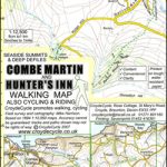 Combe Martin & Hunter`s Inn Walking Map 05
 Minehead – Dunster – Selworthy Walking Map 01
 Lynton – Lynmouth & Doone Valley Walking Map 04
 Bude – Morwenstow – Welcombe Walking Map 12
 Lyme Regis Walking Map 45 – Undercliff to Golden Cap
 Newton Ferrers – Noss Mayo & Wembury Walking Map 21
 South Devon – Brixham to Newton Ferrers OS Explorer Map OL20 (paper)
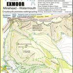 South West Coast Path Map 1 – Exmoor – Minehead – Watermouth Map 57
 South Devon – Brixham to Newton Ferrers OS Explorer Active Map OL20 (waterproof)
 Bridport & West Bay Walking Map 46 – Golden Cap to Burton Bradstock
 Exmoor & North Devon Coast Path, South-West-Coast Path Part 1: Minehead to Bude (Trailblazer British Walking Guide): Practical walking guide with 55 large-scale walking maps (1:20,000) and guides to 30 towns and villages – planning, places to stay, places
 Coast to Coast Path (Trailblazer British Walking Guide): 109 Large-Scale Walking Maps & Guides to 33 Towns & Villages – Planning, Places to Stay, Places to Eat – St Bees to Robin Hood`s Bay