Disclosure : This site contains affiliate links to products. We may receive a commission for purchases made through these links.
Dartmoor for Cyclists
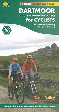
Dartmoor on a double-sided, light, waterproof and tear-resistant map providing on one side a map at 1:60,000 covering a wider area between Exeter and Plymouth, with on the reverse the Dartmoor National Park at 1:40,000 with highlighting for off-road cycle trails.On one side a map at 1:60,000 covers the area between Exeter and Plymouth. The map has contours with altitude colouring, plus colours/graphics to indicate open moorland, woodland and dense plantations. An overprint indicates roads within the National Cycle Network, as well as recommended cycle routes on minor and main roads. Also marked are off-road cycle routes, graded into easy, moderate, difficult and severe. Symbols indicate various local facilities and places of interest.On the reverse a more detailed map at 1:40,000 covers Dartmoor National Park. The map has contours at 15m intervals, plus colouring for farmland or pastures, fell or moorland, woodland, etc. Numerous off-road routes are prominently highlighted, with their colouring clearly indicating the degree of difficulty. Separate panels provide similar detailed coverage of two areas outside the national park: Tamaar Valley at 1:40,000 and Haldon Forest at 1:25,000. All the mapping has the lines of the British National Grid. The map also includes information on public transport within the region, advice and tips on safety, etc.To see the other titles in this series please click on the series link.

Related Products:
 Dartmoor National Park Pocket Map
 Dartmoor North Harvey Ultramap XT40
 Dartmoor South Harvey Ultramap XT40
 Dartmoor Goldeneye Off-Road Bike Routes
 Dartmoor National Park
 Dartmoor South Devon Cycling Country Lanes & Traffic-Free Family Routes
 Okehampton, North Dartmoor, Crediton & Bovey Tracey OS Landranger Map 191 (paper)
 North York Moors, Tees Valley & Durham Coast Sustrans Cycle Map 33
 Okehampton, North Dartmoor, Crediton & Bovey Tracey OS Landranger Active Map 191 (waterproof)
 Dartmoor Walking
 South Devon & Dartmoor
 Dartmoor – Great Short Walks for all the Family
 Photographing Cornwall and Devon: Including Dartmoor and Exmoor
 Walk! Dartmoor
 Dartmoor Harvey British Mountain Map XT40
 Dartmoor Walks
 DARTMOOR CLIMBERS CLUB
 South West Mountain Biking – Quantocks, Exmoor, Dartmoor
 North Dartmoor and Mid-Devon 1887
 Torbay & South Dartmoor 1899-1900 – 202
 Wild Swimming Walks Dartmoor and South Devon: 28 Lake, River and Beach Days Out in South West England
Okehampton and North Dartmoor 1919
Dartmoor 1908
Wild Swimming Walks Dartmoor and South Devon: 28 Lake, River and Beach Days Out in South West England
Okehampton and North Dartmoor 1919
Dartmoor 1908
 Dartmoor OS Explorer OL28 ACTIVE
 Dartmoor OS Explorer OL28
Okehampton & North Dartmoor 1899-1900 – 191
Dartmoor OS Explorer OL28
Okehampton & North Dartmoor 1899-1900 – 191
 Torbay & South Dartmoor – Totnes & Salcombe OS Landranger 202 ACTIVE
 Quartz and Feldspar: Dartmoor – a British Landscape in Modern Times
 Torbay & South Dartmoor – Totnes & Salcombe OS Landranger 202
 Coast to Coast East Mountain Bikers & Cyclists: Kirkby Stephen to Robin Hood`s Bay
Dartmoor North Harvey Superwalker XT25
Coast to Coast East Mountain Bikers & Cyclists: Kirkby Stephen to Robin Hood`s Bay
Dartmoor North Harvey Superwalker XT25
 Dartmoor South Harvey Superwalker XT25
The Peak District Sustrans Cycle Map 26 – Trans Pennine Trail – Tissington Trail – High Peak Trail
Dartmoor South Harvey Superwalker XT25
The Peak District Sustrans Cycle Map 26 – Trans Pennine Trail – Tissington Trail – High Peak Trail
 Coast to Coast West Mountain Bikers & Cyclists: St Bees to Kirkby Stephen
 Boot Up Ten Dartmoor Tors
 Boot Up Dartmoor Rivers
 Dartmoor
 Charnwood Forest Regional Park
South Dartmoor and the South Hams 1909
Charnwood Forest Regional Park
South Dartmoor and the South Hams 1909
 Mid-Wales North Sustrans Cycle Map 23