Disclosure : This site contains affiliate links to products. We may receive a commission for purchases made through these links.
Dalmatian Coast 2 – Sibenik – Split – Vis F&B
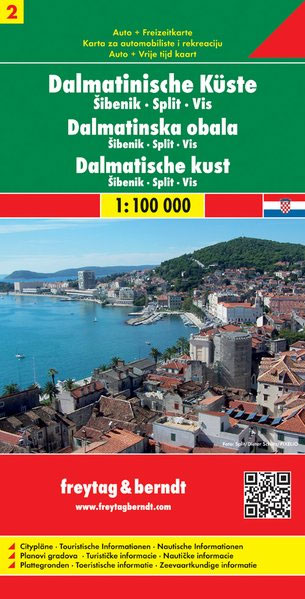
The Dalmatian Coast of Croatia between Split and Murter on a detailed, indexed map at 1:100,000 from Freytag & Berndt with large icons indicating various facilities including campsites and beaches, ferry connections, etc.Coverage includes Sibenik, Trogir and the islands of Solta and Vis. The map shows local roads, highlighting scenic routes, and indicates ferry connections. Icons mark various facilities such as campsites, beaches and marinas, as well as places of interest. The map has latitude and longitude lines at intervals of 5’. The index of place names is on the reverse where street plans of central Split, Sibenik and Trogir are also provided. Map legend includes English.The map is an enlargement of cartography prepared at a smaller scale so all place names are in larger print than usually found on similar maps. Please note: this title is not a nautical chart for sailing.

Related Products:
 Middle Dalmatian Coast 3 – Brac – Hvar – Split F&B
 Dalmatian Coast 1 – Zadar – Kornati Islands F&B
 Middle Dalmatian Coast 4 – Mljet – Medugorje – Dubrovnik F&B
 Dalmatian Coast F&B Top 10 Tips
 Croatia/Montenegro: MairDumont Marco Polo 200K Road Maps of the Dalmatian Coast
 Dalmatia – Croatia Coast Central and South
 Debrecen
 Pรฉcs
Pรฉcs
 Eger
Eger
 Cuba Michelin
 Miskolc
 Croatia – Montenegro Coast Cartographia 2-Map Set
 Nagykanizsa – Zalakaros
 Szeged
Gyor
Szeged
Gyor
 Croatian Coast K+F Road Map
 Dalmatian Coast North – Krk ‘“ Cres ‘“ Loลกinj ‘“ Rab ‘“ Pag – Zadar Kompass 2901
 Croatian Coast Flash Map-Guide
 Bangladesh & India East ITMB
 Siofok
 Bali – Lombok Nelles
 Croatia – Dalmatian Coast 3-Map Set Kompass 2900
 Croatia – Slovenia F&B Road Atlas
 Java – Jakarta Nelles
 Bulgarian and Romanian Coast
 Bali Periplus Travel Map
 Rhodes Kompass 248
Balatonfรผred – Tihany
Rhodes Kompass 248
Balatonfรผred – Tihany
 DK Eyewitness Top 10 Dubrovnik and the Dalmatian Coast
 Bay of Naples – Ischia – Capri – Amalfitana F&B
 Italy South F&B
 Arad – Timisoara Cartographia Street Plan
Croatia: Kompass 100K Maps of the Dalmatian Coast
Arad – Timisoara Cartographia Street Plan
Croatia: Kompass 100K Maps of the Dalmatian Coast
 Iceland F&B
 M26 Split to Dubrovnik
 Amsterdam Falkplan Street Plan
 Veszprรฉm
Amsterdam Falkplan Street Plan and Cycling Map
Veszprรฉm
Amsterdam Falkplan Street Plan and Cycling Map
 Kaposvar