Disclosure : This site contains affiliate links to products. We may receive a commission for purchases made through these links.
Dallas – Fort Worth Regional TX Rand McNally
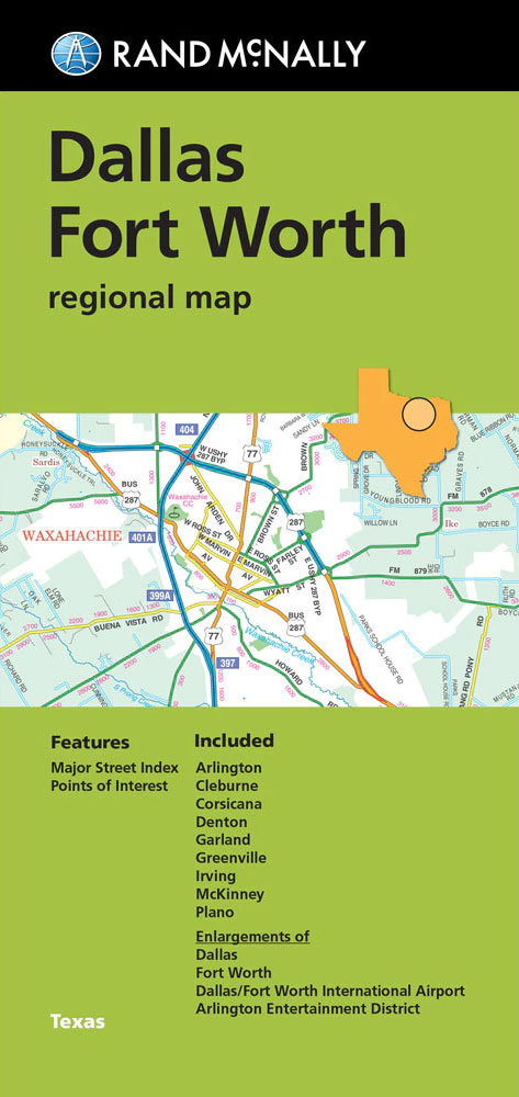
The Dallas ‘“ Fort Worth conurbation and vicinity in Texas in a series of Rand McNally’s regional road maps covering the environs of main US cities. The map covers an area centered on the two cities, extending west to Weatherford and Granbury; north to Ray Roberts Lake; east to Lake Tawakoni; and south to Hillsboro and Corsicana. Other communities covered by this map include Arlington, Cleburne, Denton, Garland, Greenville, Irving, McKinney and Plano.Maps in this series present the road network on a clear background with no relief shading to show the area’s topography, but with national or state parks, forests and other protected areas indicated by colouring. Roads are numbered and/or named, showing toll highways, exit numbers of interchanges, services and rest areas. Local airports are marked, but railways and other urban transport lines are not included unless specifically indicated in the individual description. Each town is presented in a different colour, providing those unfamiliar with the region a very clear picture of the area. Various places of interest and facilities are highlighted, including cultural and historical sites, educational institutions, sport and recreational facilities, etc. Each title is indexed. Several maps also include enlargements of the downtown area, plans of international airports, a mileage and driving times diagram for a much wider region than covered by the main map, etc – for more information please see the individual descriptions.To see all the titles in this series please click on the series link.

Related Products:
 Miami – Fort Lauderdale – West Palm Beach FL Regional Rand McNally
 Phoenix – Tucson & Vicinity AZ Regional Rand McNally
 Chicago Regional Rand McNally
 Indianapolis & Vicinity IN Regional Rand McNally
 Pittsburgh Regional PA Rand McNally
 Portland Regional Rand McNally
 Tampa – St. Petersburg – Ocala to Sarasota Regional Rand McNally
 USA: Rand McNally Regional Maps
 Denver Regional CO Rand McNally
 San Francisco Bay Area CA Regional Rand McNally
 Florida Central & Eastern Regional Rand McNally
 Houston TX Regional Rand McNally
 Detroit & Southeastern Michigan Regional Rand McNally
 Greater Boston – Eastern Massachusetts Regional Rand McNally
 Philadelphia & Southeast Pennsylvania Regional Rand McNally
 Puget Sound WA Regional Rand McNally
 New York City & Long Island Regional Rand McNally
 Los Angeles & San Diego Vicinity CA Regional Rand McNally
 Fort Worth TX Rand McNally
Charlotte NC Rand McNally
Fort Worth TX Rand McNally
Charlotte NC Rand McNally
 Dallas TX Rand McNally
 Fort Myers – Cape Coral FL Rand McNally
 Fort Lauderdale Metro FL Rand McNally
 Moon Dallas & Fort Worth
 Moon Dallas & Fort Worth (Second Edition)
 USA: Rand McNally Street Plans / Regional Maps
 Salt Lake City UT Rand McNally
 New Orleans LA Rand McNally
 Utah Easy-to-Read Rand McNally
 Anchorage – Fairbanks – Juneau – Ketchikan AK Rand McNally
 Kansas City MO/KS Rand McNally
 Nevada Easy-to-Read Rand McNally
 Sacramento CA Rand McNally
 San Diego CA Rand McNally
 Des Moines – Ames IA Rand McNally
 Portland OR Rand McNally
 Seattle WA Rand McNally
 Boise – Nampa – Caldwell ID Rand McNally
 Milwaukee WI Rand McNally
 Louisville KY Rand McNally