Disclosure : This site contains affiliate links to products. We may receive a commission for purchases made through these links.
Czechia Shocart 75K Cycling Atlas
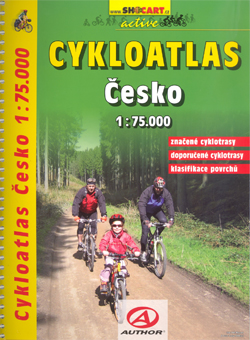
Czech Republic Cycling Atlas at 1:75,000 from Shocart in an A4 spiral-bound format, providing a detailed picture of the country’s extensive network of waymarked cycling paths, including routes in the adjoining areas of the neighbouring countries.Topography is shown by contours at 20m intervals with spot heights and relief shading, complemented by colouring and graphics to show different types of terrain or vegetation: peat bogs, forests, orchards, hop fields, vineyards, etc. National parks and other protected area are marked.Extensive overprint highlights cycle routes with, as appropriate, route numbers, names or waymarking symbols, indicating sections suitable for only for mountain bikes, danger points, intermediate distances, etc. Hiking trails are also marked. The maps show the country’s road network with locations of petrol stations, railways, and highlight various places of interest, campsites, etc. The maps have latitude and longitude grid lines at intervals of 1’. The atlas is indexed and its *map legend includes English.*

Related Products:
 Czechia Shocart 50K Tourist Atlas
 Czech Republic 100K Cycling Atlas
 Netherlands Falkplan Cycling Atlas
 Saltzkammergut Cycling Atlas
The Ruhr Bikeline Cycling Atlas
Burgenland Bikeline Cycling Atlas
Moststrasse Cycling Atlas
East Tyrol Cycling Atlas
Saltzkammergut Cycling Atlas
The Ruhr Bikeline Cycling Atlas
Burgenland Bikeline Cycling Atlas
Moststrasse Cycling Atlas
East Tyrol Cycling Atlas
 Rheinhessen Cycling Atlas
 Environs of Hamburg Cycling Atlas
 Hamburg Cycling Atlas
 Cologne – Bonn – Bergische Land Cycling Atlas
 Munich and Environs Cycling Atlas
Nuremberg and Environs Cycling Atlas
Szczecin Lagoon – Usedom Circular Cycling Routes Atlas
Munich and Environs Cycling Atlas
Nuremberg and Environs Cycling Atlas
Szczecin Lagoon – Usedom Circular Cycling Routes Atlas
 Rhine – Neckar Cycling Atlas
 Lake Balaton Cycling Atlas
 Slovakia Shocart 50K Tourist Atlas
 Cycling Atlas Europe: The 350 Most Beautiful Cycling Routes in Europe
 Czech Republic Road Atlas
 Netherlands Cycling Atlas Slim Format
 Slovenia: Kompass 75K Hiking and Cycling Maps
 Istria Region Bikeline Cycling Atlas
 Czech Republic 100K Tourist Road Atlas
 Umbria Bikeline Cycling Atlas (1020km)
 Austria F&B Road Atlas
 Austria: Freytag & Berndt Cycling Maps
 East Frisia Cycling Region Bikeline Map-Guide
 Germany – Benelux – Austria – Czechia Michelin
 Hamburg Surroundings Bikeline Cycling Map-Guide
Netherlands Cycling Atlas
Rhine – Main River Cycle Atlas
Carinthia Cycling Region Bikeline Map-Guide
Hamburg Surroundings Bikeline Cycling Map-Guide
Netherlands Cycling Atlas
Rhine – Main River Cycle Atlas
Carinthia Cycling Region Bikeline Map-Guide
 Belgian Coast Cycling Map 30
 Veluwe Falkplan Cycling Map 09
 Belgian Limburg Cycling Map
 Twente Falkplan Cycling Map 08
 Achterhoek Falkplan Cycling Map 10
Austria: Bikeline Cycling Atlases
Achterhoek Falkplan Cycling Map 10
Austria: Bikeline Cycling Atlases
 Geneva K+F Cycling Map 17