Disclosure : This site contains affiliate links to products. We may receive a commission for purchases made through these links.
Czechia Michelin
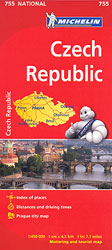
The Michelin National road map of the Czech Republic at 1:450,000 scale is ideal for route planning and touring. The map gives comprehensive coverage of national road networks showing all major motorways, dual carriageways, national & regional main roads and most single-lane roads. The map is divided by grid showing latitude and logitude.Distances between major locations are marked along roads, with total distance and several intermediate distances shown. A quick-reference chart of distances & driving times between major locations is also included. The map also includes a grid-referenced index of principal place names.Clear, easy-to read cartography shows roads in reds, yellows and white with black outlines. Major topography is indicated with relief shading. Woodland & forest is marked with green shading. Built-up urban areas are clearly marked in yellow. Airports, ferries, railways are also marked. National and administrative divisions are marked, as are administrative district seats. Areas of special interest, such as churches and museums, are also displayed.City plan plans & regional enlargements:- Praque at 1:100,000 scale.

Related Products:
 Czechia – Slovakia Michelin
 Czechia – Slovakia Michelin SUPERCEDED
 Baltic States Michelin
 Finland Michelin
 Sweden Michelin
 Norway Michelin
 Hungary Michelin
 Portugal – Madeira Michelin
 Austria Michelin
 Poland Michelin
 Romania Michelin
 Slovenia – Croatia – Bosnia-Herzegovina – Serbia – Montenegro – North Macedonia Michelin
 Ivory Coast Michelin
 Germany – Benelux – Austria – Czechia Michelin
 Greece Michelin
 Czechia
 Latvia Regio Manors and Palaces
 Southeastern USA Michelin Regional 584
 Wales – South West England – Midlands Michelin Regional 503
 Northern England – Midlands Michelin Regional 502
 Great Britain: Michelin 400K Road Maps
 Baden-Wรผrttemberg Official Road Map
 South East England – Midlands – East Anglia Michelin Regional 504
 USA: Michelin Regional Road Maps
 Benelux Michelin
 Turkey Michelin
 Czechia Shocart 75K Cycling Atlas
 Northeastern USA – Eastern Canada Michelin Regional 583
 Paris & Surrounding Areas Michelin Regional 514
 Czechia Michelin 755
 Western USA – South Western Canada Michelin Regional 585
 Galicia Michelin Regional 571
 Africa: Michelin Sectional Maps
 Balearic Islands Michelin Regional 579
 Andalucia Michelin Regional 578
 Poland: Michelin Regional Road Maps
 Castilla y Leon – Madrid Michelin Regional 575
 Comunidad Valenciana – Murcia Michelin Regional 577