Disclosure : This site contains affiliate links to products. We may receive a commission for purchases made through these links.
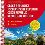
Czech Republic F&B Superatlas

Czech Republic Road Atlas at 1:150,000 from Freytag & Berndt’s Prague based subsidiary with clear, well presented cartography and road information, large street plans of the country’s 13 main cities, plus coverage of the whole of Europe at 1:3,500,000.Road network is graded into six different types of roads, with driving distances on all but the smallest country lanes, locations of petrol stations and gradient markings. Names and numbers of motorway junctions are clearly presented and service areas are marked. Railway lines are shown with stations.Picturesque towns or villages and other particularly interesting sights are highlighted, and symbols mark locations of campsites, etc. Topography is shown by relief shading and spot heights, with colouring for forested areas and names of mountain ranges. National parks and other protected areas are highlighted. Also shown are restricted entry military zones. The maps have latitude and longitude lines at intervals of 10’ and the atlas has a 25-page index which also gives postcodes.Map legend includes English.Street plans, each covering a whole page, show 13 of the country’s towns, highlighting main traffic arteries, parking facilities and various places of interest or services in Prague (on two pages), Brno, Ceske Budejovice, Hradec Kralove, Jihlava, Karlovy Vary, Liberec, Olomouc, Ostrava, Pardubice, Plzen, Usti nad Labem and Zlin. The atlas also has a comprehensive distance table, a list of UNESCO World Heritage sites, and driving regulations.In common with most country road atlases from Central European publishers, this title also includes an indexed section covering the whole of Europe at 1:3,500,000 for route planning.


