Disclosure : This site contains affiliate links to products. We may receive a commission for purchases made through these links.
Cuba ITMB

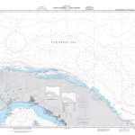
Cuba at 1:600,000 on a double-sided indexed map from ITMB printed on light, waterproof and tear-resistant plastic paper, with street plans of central Havana, central Santiago de Cuba and the Varadero Peninsula.The map is double-sided, dividing the country west/east with a good overlap between the sides. Altitude colouring with spot heights indicate the topography, with swaps, seasonal rivers, and coastal reefs also marked. The map shows Cuba’s road network including selected local roads and country tracks with locations of petrol stations and driving distances on main routes. Railway lines are included and local airports are marked. Also shown are internal administrative boundaries and names of the provinces (including the US base at Guantanamo). Symbols highlight places of interest, including campsites and selected accommodation, beaches and diving sites, viewpoints, caves, etc, some annotated with brief descriptions. Latitude and longitude lines are drawn at 30’ intervals. Each side has a separate index.Street plans, annotated with places of interest, services and accommodation, show central Havana (including the Old Town) and central Santiago de Cuba. The map also includes a street plan of the Varadero Peninsula tourist complex, naming numerous hotels, restaurants, beaches, etc.

Related Products:
 Cuba West ITMB
 Cuba Borch
 Cuba terraQuest Adventure Map
 Cuba Nelles
 Cuba Gizi Map
 Cuba Wall Map
 Cuba Michelin
 Cuba Marco Polo Map
 Cuba East ITMB
 Chile ITMB
 Havana & Cuba Central ITMB
 Santiago & Chile North ITMB
 Easter Island & Santiago ITMB
 Namibia ITMB
 Algeria ITMB
 Caribbean Islands Western Half ITMB Travel Atlas
 Cuba NGS Adventure Map 3112
 Baja California ITMB
 Pakistan ITMB
 Cayman Islands & Jamaica ITMB
 Belarus ITMB
 Romania & Moldova ITMB
 Australia ITMB
 Georgia & Armenia ITMB
 Armenia & Azerbaijan ITMB
 South Africa – Lesotho – Swaziland ITMB
 Sarawak – Sabah – Brunei ITMB
 Peru ITMB
 Tahiti & Cook Islands ITMB
 Thailand, Vietnam, Laos & Cambodia ITMB Travel Atlas
 Middle East ITMB Travel Atlas
 Morocco ITMB
 Czech Republic ITMB
 Sri Lanka & India South ITMB
 Tanzania ITMB
 Taiwan & Taipei ITMB
 Ghana ITMB
 Southern Vietnam – Mekong Delta ITMB
 Senegal & Gambia ITMB