Disclosure : This site contains affiliate links to products. We may receive a commission for purchases made through these links.
Croatia – Dalmatian Coast 3-Map Set Kompass 2900
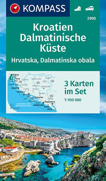
The Dalmatian Coast of Croatia and Montenegro on a set of three double-sided, detailed and GPS compatible maps at 1:100,000 from Kompass. Combined coverage of the three maps extends from Rijeka to the Albanian border.The maps have contours at 40m intervals, enhanced by relief shading and spot heights. Road network includes unsurfaced country roads and cart tracks, and indicates locations of petrol stations. Railway lines are shown with stations and ferry routes are marked. An overprint highlights a selection of waymarked hiking trails. Picturesque towns and villages are highlighted and symbols mark various places of interest, including selected hotels, campsites and mountain huts, viewpoints, cultural and archaeological sites, etc. Also shown are harbours, marinas, restricted anchorage sites and locations of nautical fuel suppliers. The legend, conveniently placed on each side of the map, includes English.PLEASE NOTE: to see the individual maps from this set please click on the series link. For convenience, we have also listed with this series Kompass map of Istria at 1:75,000 (No. 238) which has the publishers’ traditional cartography, markedly different from the other three maps (Nos. 2901 ‘“ 2903).

Related Products:
 Croatia: Kompass 100K Maps of the Dalmatian Coast
 Dalmatian Coast North – Krk ‘“ Cres ‘“ Loลกinj ‘“ Rab ‘“ Pag – Zadar Kompass 2901
 Croatia/Montenegro: MairDumont Marco Polo 200K Road Maps of the Dalmatian Coast
 Dalmatia: Recipes from Croatia`s Dalmatian Coast
 Middle Dalmatian Coast 3 – Brac – Hvar – Split F&B
 Dalmatian Coast 2 – Sibenik – Split – Vis F&B
 Dalmatian Coast 1 – Zadar – Kornati Islands F&B
 Middle Dalmatian Coast 4 – Mljet – Medugorje – Dubrovnik F&B
 Dalmatian Coast F&B Top 10 Tips
 DK Eyewitness Top 10 Dubrovnik and the Dalmatian Coast
 Croatia ITMB
 Dubrovnik & Dalmatian Coast Marco Polo Pocket Travel Guide 2019 – with pull out map
 Croatia – Montenegro Coast Cartographia 2-Map Set
 Istria Kompass 238
 Croatia Coast – Istria – Dalmatia – Dubrovnik F&B
 Dalmatia – Croatia Coast Central and South
 Lonely Planet Pocket Dubrovnik & the Dalmatian Coast
 Slovenia – Croatia – Serbia – Bosnia-Herzegovina – Macedonia – Kosovo – Montenegro F&B
 Croatia: Freytag & Berndt Maps of the Croatian Coast
 South Tyrol Kompass Hiking & Recreational Kompass Ring-binder Atlas No. 2703: Bormio – Merano – Bolzano – Cortina d`Ampezzo
Croatian Coast K+F Road Map
South Tyrol Kompass Hiking & Recreational Kompass Ring-binder Atlas No. 2703: Bormio – Merano – Bolzano – Cortina d`Ampezzo
Croatian Coast K+F Road Map
 Maremma Coast – Piombino – Follonica – Castiglione della Pascaia Kompass 2469
 Baltic Coast Coast – Lubeck to the Danish Border 2-Map Set Kompass 724
 Luxembourg 2-Map Set Kompass 2202
 Madeira Kompass 234
 Coast Around Lisbon Turinta
 Sorrento Peninsula – Amalfi Coast – Vesuvius – Pompeii – Salerno – Sorrento Kompass 682
 Venetian Republic: Recipes and stories from the shores of the Adriatic, the Dalmatian Coast and the Greek islands
 777 Harbours and Anchorages ed. 2017/18 – Slovenia, Croatia, Montenegro and Albania (Eastern Adriatic)
 Azores 2-Map Set Kompass 2260
 Maribor – Pomurje – Drava Valley Kompass 2802
 Dalmatia 2-Map Set
 Germany and Alpine Regions of Europe: Kompass Maps of Long-distance Footpaths
 Julian Alps – Steiner Alps – Kamnik Alps Kompass 2801
 Kos – Southern Dodecanese Kompass 252
 Allgรคu 35K Kompass Hiking Atlas No.2751
 Klaipeda and the Northern Coast
Hermannsweg und Eggeweg – die Hermannshohen Kompass Long-distance Trail Map 2504
Slovenia: Kompass 75K Hiking and Cycling Maps
Klaipeda and the Northern Coast
Hermannsweg und Eggeweg – die Hermannshohen Kompass Long-distance Trail Map 2504
Slovenia: Kompass 75K Hiking and Cycling Maps
 North Sea Coast – Hamburg to Denmark 2-Map Set Kompass 723