Disclosure : This site contains affiliate links to products. We may receive a commission for purchases made through these links.
Coventry – Rugby A-Z Street Atlas
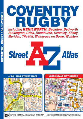
This A-Z map of Coventry and Rugby features 45 pages of continuous street mapping extending to:Bedworth, Bulkington, Keresley, Allesley, Baginton, Coventry Airport, Kenilworth, Wolston, Long Lawford, Clifton upon Dunsmore, Kilsby, Crick, DunchurchAlso included are inset maps of Meriden, Brownsover and Thurlaston and a large scale city centre map of Coventry.Postcode districts, one-way streets and safety camera locations with speed limits are also featured on the mapping.The index section lists streets; selected flats, walkways and places of interest; place, area and station names; hospitals and hospices covered by this atlas.

Related Products:
 Liverpool A-Z Street Atlas
 Norwich A-Z Street Atlas
 Manchester A-Z Street Atlas
 Merseyside A-Z Street Atlas
 Bournemouth A-Z Street Atlas
 Nottingham – Ilkeston – Long Eaton – West Bridgford A-Z Street Atlas
 Greater Manchester A-Z Street Atlas
 Southampton – Eastleigh – Fawley – Hythe – Romsey A-Z Street Atlas
 Birmingham A-Z Street Atlas
 Newcastle upon Tyne A-Z Street Atlas
 Ipswich – Felixstowe A-Z Street Atlas
 Southampton A-Z Street Atlas
 Cardiff A-Z Street Atlas
 Canterbury – Margate – Ramsgate A-Z Street Atlas
 Brighton and Worthing A-Z Street Atlas
 Edinburgh A-Z Street Atlas
 Nottingham A-Z Street Atlas
 Portsmouth A-Z Street Atlas
 Cambridge A-Z Handy Map
 Bath A-Z Handy Map
 Taunton A-Z Street Atlas
 Plymouth A-Z Handy Map
 West Midlands – Birmingham – Coventry – Wolverhampton A-Z Street Atlas
 Edinburgh A-Z Handy Map
 Greater London A-Z Master Atlas
 Glasgow Premier A-Z Wall Map PAPER
 London A-Z Big Street Atlas
 London A-Z Street Atlas
 Edinburgh Premier A-Z Wall Map PAPER
 Newcastle upon Tyne Premier A-Z Wall Map
 Zurich Street Atlas
 Leicester, Coventry & Rugby OS Landranger Map 140 (paper)
 Leicester, Coventry & Rugby OS Landranger Active Map 140 (waterproof)
 Prague Street Atlas
 Riga and Vicinity Jana Seta Street Atlas
 Bucharest Street Atlas
 Aberdeen A-Z Street Atlas
 London A-Z Map
 Coventry A-Z Street Plan Wall Map
 Kingston upon Hull – Barton-upon-Humber – Beverley A-Z Street Atlas