Disclosure : This site contains affiliate links to products. We may receive a commission for purchases made through these links.
Coventry A-Z Street Plan Wall Map
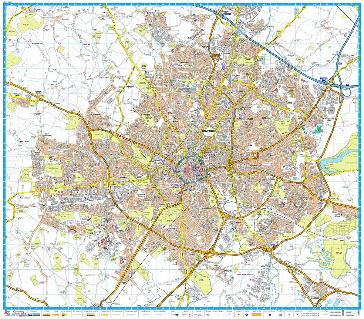
This Street Map of Coventry is extracted from A-Z digital data to ensure that the latest A-Z revision is available as a printed sheet map.The map area covers:Keresley NewlandsCoventryM6 Junction 3Walsgrave on StoweBinley WoodsRyton-on-DunsmoreCoventry AirportMillison`s WoodTile HillA-Z Street Mapping includes:Distinctive road classification coloursUnder construction and proposed roadsOne-way streetsRailway and other transport networksCategorised buildingsPlaces of Interest

Related Products:
 Portsmouth A-Z Street Plan Wall Map
 Southampton A-Z Street Plan Wall Map
 Birmingham A-Z Street Plan Wall Map
 Cardiff A-Z Street Plan Wall Map
 Liverpool A-Z Street Plan Wall Map
 Nuremberg Falk EXTRA Street Plan
 Linz F&B Tourist Street Plan
Bremen Falk EXTRA Street Plan
Hanover Falk EXTRA Street Plan
Linz F&B Tourist Street Plan
Bremen Falk EXTRA Street Plan
Hanover Falk EXTRA Street Plan
 Leeds A-Z Street Plan Wall Map
 Salzburg F&B Tourist Street Plan
Trier Falk EXTRA Street Plan
Frankfurt am Main Falk EXTRA Street Plan
Salzburg F&B Tourist Street Plan
Trier Falk EXTRA Street Plan
Frankfurt am Main Falk EXTRA Street Plan
 Plymouth A-Z Street Plan Wall Map
 Salzburg F&B Street Plan
 Coventry – Rugby A-Z Street Atlas
 Haarlem Falkplan Street Plan
 Leicester A-Z Street Plan Wall Map
 Sheffield A-Z Street Plan Wall Map
 Iasi Cartographia Street Plan
 Riga City Center Jana Seta Street Plan
Buenos Aires Street de Dios Street Plan
Riga City Center Jana Seta Street Plan
Buenos Aires Street de Dios Street Plan
 Paris Michelin Street Plan
 West Midlands – Birmingham – Coventry – Wolverhampton A-Z Street Atlas
 Padua TCI Street Plan
 Pau Blay-Foldex Street Plan
 Sofia Domino Street Plan
 Bangkok Walks Street Plan
 Vienna F&B Tourist Street Plan
Palermo TCI Street Plan
Vienna F&B Tourist Street Plan
Palermo TCI Street Plan
 Hyรจres Blay-Foldex Street Plan
 Mรขcon Blay-Foldex Street Plan
 Lyon Blay-Foldex Street Plan
 Marseille Blay-Foldex Street Plan
 Rennes Blay-Foldex Street Plan
 Beziers Blay-Foldex Street Plan
 Mulhouse Blay-Foldex Street Plan
 Carcassonne Blay-Foldex Street Plan
 Chartres Blay-Foldex Street Plan
 Bourges Blay-Foldex Street Plan