Disclosure : This site contains affiliate links to products. We may receive a commission for purchases made through these links.
Cotopaxi
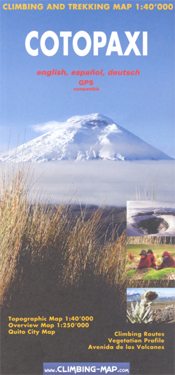
Cotopaxi at 1:40,000 on an excellent map combining topographic coverage of the mountain with panorama maps showing the two approaches to the summit, a road map of the region, a street plan of Quito, information on vegetation an geology, etc.On one side is a map of Cotopaxi at 1:40,000 with showing routes to the summit. Contours are at 40m intervals, enhanced by relief shading, spot heights, graphics and colouring showing exposed rock, scree, and icefields, plus different types of vegetation: shrubs, grass and swamps. Climbing routes to the summit and other tracks are marked. Symbols highlight locations suitable for camping. The map has a 1km UTM grid, plus margin ticks for latitude and longitude.On the reverse two panorama views show the north and the south face of the mountain highlighting the routes to the summit, accompanied by brief descriptions, plus a list of GPS waypoints for the northern Normal Route.All the text is in English. Main map legend and route descriptions are also in Spanish and German.The map also includes:* A regional map at 1:250,000 with altitude colouring, showing access by road and rail from Quito.* A street plan of Quito with an enlargement of the New Town, annotated with facilities and services including lists of travel agencies for trekking and mountaineering, and equipment shops.* Insets showing a panorama of vegetation zones with drawings of fauna and flora; information on corps grown at different altitudes; geological profile of Cotopaxi and retreat of glaciation.* A panorama map of the Avenida de los volcanes, plus separate insets showing Imbabura, Cayambe, Pichincha, Ilinizas and Chimborazo at approx. 1:150,000 with altitude colouring, roads and trails, plus camping sites and refuges.

Related Products:
 Aconcagua Climbing and Trekking Map
 Galapagos Islands – Quito & Guayaquil ITMB
 Quito & Central Ecuador ITMB
 Whistler and Sea-to-Sky Highway ITMB
 Gibraltar – Strait of Gibraltar ITMB
 Auckland & North Island ITMB
 Samokov – Borovets with the Rila Mountains
 Japan North & Hokkaido ITMB
 Kilimanjaro – Kibo
 Vilnius Briedis Street Plan and Panorama
 Iran & Tehran ITMB
 Cรกdiz
Palencia
Cรกdiz
Palencia
 Smolyan – Chepelare – Pamorovo and the Surrounding Area
 Pakistan ITMB
 Aconcagua – Summit of South America
 Bulgaria (with Mountain Resorts)
 Kilimanjaro National Park
 Zurich & Switzerland NW ITMB
 Brisbane & Queensland ITMB
 Alberta ITMB
 Kilimanjaro – Summit of Africa
 Turkmenistan Gizi Map
 Switzerland, My Holiday Map
 Mandalay & Myanmar (Burma) Odyssey Map
 New Zealand ITMB
Garden Route & Route 62 Map Studio
New Zealand ITMB
Garden Route & Route 62 Map Studio
 Kopaonik
 Sikkim & India Northeast ITMB
 Syria – Lebanon
Turkmenistan Gizi Wall Map
Syria – Lebanon
Turkmenistan Gizi Wall Map
 Ecuador Borch
 Jordan
 Okinawa & the Ryukyu Islands Periplus Travel Map
 Explore Mount Kilimanjaro
 Mont Blanc 4810m – 5 Routes to the Summit
 Yangon & Myanmar (Burma) Odyssey Map
 Fogo – Brava AB Kartenverlag Hiking Map