Disclosure : This site contains affiliate links to products. We may receive a commission for purchases made through these links.
Costa Rica NGS Adventure Map 3100
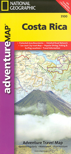
Costa Rica on a double-sided, waterproof and tear-resistant map with a street plan of central San Josรฉ, produced by the National Geographic Society in cooperation with the Instituto Geogrรกfico Nacional, Costa Rica’s national survey organization.The country is divided east/west, with a generous overlap between the two sides. Topography is shown by contours at 100m intervals, enhanced by relief shading and spot heights. Along the coast reefs, rocks and shallow water areas are marked. The map indicates various types of vegetation: forests, palm forest, mangrove, and fresh or salt water swamps. Road network includes gravel tracks and indicates roads passable only in summer. Railways and local airstrips are marked, as well as the country’s internal administrative boundaries together with names of the provinces. The map highlights seven different types of protected areas: national wildlife refuges, protection zones, wetlands, national parks, forest reserves, biological reserves, and absolute nature reserves, plus national monuments, all listed in a special index. A UTM grid is printed on the map, plus latitude and longitude margin ticks at 10` intervals.The map includes a street plan of central San Josรฉ, naming principal streets and districts, and highlighting various places of interest to visitors. Also included are enlargements for Isla del Coco, Isla del Caรฑo, an overview map of Central America, and an index of selected towns.

Related Products:
 Costa Rica NGS Wall Map PAPER
 Costa Rica NGS Wall Map ENCAPSULATED
 Costa Rica F&B
 Costa Rica Borch
 Costa Rica Travel Map
 National Geographic Costa Rica, 6th edition
 Costa Rica
 Costa Rica Michelin
 Costa Rica Footprint Handbook
 Costa Rica Traveler Guide
 Costa Rica: A Traveler`s Literary Companion
 Where to Watch Birds in Costa Rica
 Costa Rica in Focus
 The Rough Guide to Costa Rica
Costa Rica Reise Know-How
The Rough Guide to Costa Rica
Costa Rica Reise Know-How
 Costa Rica – Panama Reise Know-How
 Costa Rica: Travellers` Wildlife Guide
 Moon Living Abroad Costa Rica
 Costa Rica hand flag
 Rio San Juan: Nicaragua – Costa Rica Border Regions
 A Naturalist`s Guide to the Birds of Costa Rica (2nd edition)
 Costa Rica Eyewitness
 Moon Costa Rica (First Edition)
 DK Eyewitness Travel Guide Costa Rica
 Costa Rica Marco Polo Pocket Travel Guide 2019 – with pull out map
 Birds of Costa Rica
 Costa Rica – Charlie`s Charts Cruising Guide
 Butterflies, Moths and other Invertebrates of Costa Rica
 The Costa Rica Reader: History, Culture, Politics
 Insight Guides Costa Rica
Costa Rica IGN 85133
Insight Guides Costa Rica
Costa Rica IGN 85133
 Costa Rica National Flag – 1/2 yard – Printed
 Lonely Planet Best of Costa Rica
 Costa Rica, Nicaragua & Panama Footprint Handbook
 Lonely Planet Costa Rica
 Birds of Central America: Belize, Guatemala, Honduras, El Salvador, Nicaragua, Costa Rica, and Panama
 Costa Rica – Culture Smart!
 Nature`s Paradise: Costa Rica
 Flag of Costa Rica