Disclosure : This site contains affiliate links to products. We may receive a commission for purchases made through these links.
Costa Rica ITMB
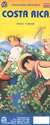
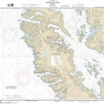
Costa Rica on a waterproof and tear-resistant map from ITMB at 1:300,000, with a plan of central San Josรฉ, an enlargement for the environs of the capital, and a separate index of place names for each side of the map. The country is divided north/south, with a very generous overlap and San Josรฉ included on both sides. The map has altitude colouring, with contours above 1000m plus spot heights. Provincial boundaries, railways, and local airstrips and landing grounds are marked. Road network includes seasonal tracks, and indicates locations of petrol stations. National parks and protected areas are marked, and symbols highlight selected accommodation, archaeological sites, museums, beaches and surfing sites, bird sanctuaries, etc. Latitude and longitude grid is drawn at 15’ intervals. Each side of the map has a separate index of place names.The map also includes a street plan of San Josรฉ with names of both streets and districts, and an overprint highlighting accommodation, plus services and places of interest. Enlargements show the environs of the city and the Isla del Coco in greater detail.

Related Products:
 Costa Rica Borch
 Costa Rica
 Costa Rica F&B
 Costa Rica NGS Adventure Map 3100
 Costa Rica Reise Know-How
 Costa Rica – Panama Reise Know-How
 Costa Rica Travel Map
 Insight Guides Costa Rica
 A Naturalist`s Guide to the Birds of Costa Rica (2nd edition)
 Costa Rica, Nicaragua & Panama Footprint Handbook
 Costa Rica Michelin
 The Rough Guide to Costa Rica
Costa Rica Footprint Handbook
The Rough Guide to Costa Rica
Costa Rica Footprint Handbook
 Insight Guides Explore Costa Rica
 Where to Watch Birds in Costa Rica
 Costa Rica NGS Wall Map PAPER
 The Costa Rica Reader: History, Culture, Politics
 Costa Rica NGS Wall Map ENCAPSULATED
New Zealand ITMB
Costa Rica NGS Wall Map ENCAPSULATED
New Zealand ITMB
 Madagascar ITMB
 Costa Rica – Charlie`s Charts Cruising Guide
 Bahamas ITMB
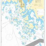
 Rio San Juan: Nicaragua – Costa Rica Border Regions
 Birds of Costa Rica
 Taiwan & Taipei ITMB
 Central America ITMB
 Saudi Arabia & Kuwait ITMB
 Costa Rica Marco Polo Pocket Travel Guide 2019 – with pull out map
 Costa Rica in Focus
 Frommer`s Costa Rica
 Dominican Republic & Haiti ITMB
 Virgin Islands (US and British) ITMB
 Costa Rica Eyewitness
 Cayman Islands & Jamaica ITMB
 Costa Rica hand flag
 Cuba ITMB
 Butterflies, Moths and other Invertebrates of Costa Rica
 Bangkok & Thailand South ITMB
 Jerusalem & Holy Land ITMB