Disclosure : This site contains affiliate links to products. We may receive a commission for purchases made through these links.
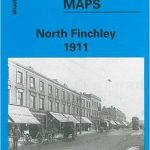
Colwyn Bay North 1911
Colwyn Bay North in 1911 in a fascinating series of reproductions of old Ordnance Survey plans in the Alan Godfrey Editions, ideal for anyone interested in the history of their neighbourhood or family. The map is double-sided. The main map covers the northern part of Colwyn Bay, stretching from Penrhyn Road westward to Bryn Euryn and Bron-y-nant, and northward to Rhos Road. Features include a stretch of the LNWR railway, Colwyn Bay Hotel, St John`s church, Rydal Mount, Ratonagh, Penrhos College, St Joseph`s RC church, Bryn Euryn, Llys Euryn, Glan-y-wern, tramway, Walshaw etc. On the reverse is the adjacent sheet 3.04 which extends coverage eastward to include the station, Victoria Pier and Promenade.About the Alan Godfrey Editions of the 25″ OS Series:Selected towns in Great Britain and Ireland are covered by maps showing the extent of urban development in the last decades of the 19th and early 20th century. The plans have been taken from the Ordnance Survey mapping and reprinted at about 15 inches to one mile (1:4,340). On the reverse most maps have historical notes and many also include extracts from contemporary directories. Most maps cover about one mile (1.6kms) north/south, one and a half miles (2.4kms) across; adjoining sheets can be combined to provide wider coverage.FOR MORE INFORMATION AND A COMPLETE LIST OF ALL AVAILABLE TITLES PLEASE CLICK ON THE SERIES LINK.

Related Products:
 Colwyn Bay South East 1911
Colwyn Bay South West 1911
Colwyn Bay South East 1911
Colwyn Bay South West 1911
 North Finchley 1911
 Enfield Highway 1911
 Alexandra Park & South Friern 1911 – 6b
 Hanworth and North West Hampton 1934
Croydon Woodside 1911
Hanworth and North West Hampton 1934
Croydon Woodside 1911
 Enfield (NW) 1911 – 7.02
 Coombe and Norbiton 1911
 Knutsford North 1908
North Shields and Chirton 1894
Knutsford North 1908
North Shields and Chirton 1894
 Mid Finchley 1911
 Bromley Common and North-East Hayes 1895
Nottingham North 1913
North Surbiton and South Kingston 1932
Bromley Common and North-East Hayes 1895
Nottingham North 1913
North Surbiton and South Kingston 1932
 Tredegar North 1899
 Cambridge (North) 1901 – 40.14
Carshalton & North Wallington 1910 – 13.12
Cambridge (North) 1901 – 40.14
Carshalton & North Wallington 1910 – 13.12
 Tottenham (North) 1894 – 8a
Darlington North 1896
Tottenham (North) 1894 – 8a
Darlington North 1896
 Kirkby Stephen 1911 – 23.15
Carlisle North-East 1924
Plymouth North 1893
Southport (North) 1909 – 75.06b
Birmingham Central 1902-1911
Wolverhampton North West 1901
Kirkby Stephen 1911 – 23.15
Carlisle North-East 1924
Plymouth North 1893
Southport (North) 1909 – 75.06b
Birmingham Central 1902-1911
Wolverhampton North West 1901
 Richmond North 1927
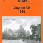 Croydon North-East 1895
 Bromley North and Sundridge Park 1895
 Sevenoaks North and Riverhead 1907
Leicester South West 1902-1911
Northfield North 1903
Wrexham North 1909
Hurst and North Ashton 1906
East Finchley & Hampstead Garden Suburb 1894-1911 – 10.3
North Finchley 1894
Sevenoaks North and Riverhead 1907
Leicester South West 1902-1911
Northfield North 1903
Wrexham North 1909
Hurst and North Ashton 1906
East Finchley & Hampstead Garden Suburb 1894-1911 – 10.3
North Finchley 1894
 Warwick North 1923
 Ebbw Vale North 1899
Motherwell (North) 1939 – 12.09
Ebbw Vale North 1899
Motherwell (North) 1939 – 12.09
 Beverley North 1908