Disclosure : This site contains affiliate links to products. We may receive a commission for purchases made through these links.
Colombia/Venezuela/Panama: North 8ยฐ-16ยฐ / West 70ยฐ-82ยฐ
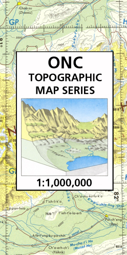
Map No. K-26 in the ONC series: military topographic survey mapping covering the world`s land masses and significant islands at 1:1,000,000. The maps are useful as general topographical coverage where nothing else is available, although they are designed primarily as flying charts for military aircraft. ONC stands for Operational Navigation Chart.Relief is portrayed by a combination of contours (basic interval 1000ft, intermediate contours shown where appropriate), elevation tinting and relief shading, plus spot heights. Towns, villages, major roads, railways and airports are shown but please note that many of the smaller settlements are not named and the road information is not necessarily up to date, as compilation and revision dates vary. Some air navigation information also appears on the map, such as radio beacons and restricted flying zones. Each ONC chart has both UTM and latitude/longitude grids overprinted on it, with additional margin ticks. *IMPORTANT – PLEASE NOTE:** *The series is gradually being withdrawn from sale to the general public and some sheets may no longer be available when ordered by us.** Due to the nature of the map projection assembling these sheets to make a larger map is not recommended. Additionally, colours used for relief are not constant throughout the series.* In some areas of central Africa and South America the maps have blank spaces, reflecting localized deficiencies or inconsistencies in the survey data.

Related Products:
 World-wide Topographic Map Series – ONC
 NGA Chart 28053 – Boca del Drago – Panama (North Coast)
 Switzerland North West Swisstopo 1
 Iceland North-West IDNU 1
 Shetland: Mainland North West – North Roe & Sullom Voe OS Explorer Map 469 (paper)
 Shetland: Mainland North West – North Roe & Sullom Voe OS Explorer Active Map 469 (waterproof)